
Sleeping Bear Dunes National Lakeshore
Established as a national park in 1970, the Sleeping Bear Dunes National Lakeshore is the largest freshwater system of sand dunes in the world. It was named The Most Beautiful Place in America by Good Morning America in 2011. As an ecosystem, it is unlike any other in the state of Michigan and a stunning place to visit.
We departed the hotel at 8:00 am, our pockets full of protein bars scavenged from the hotel's breakfast service. We drove 30 minutes west to arrive at the Philip A. Hart Visitor's Center and watched an introductory video about the dunes featuring descendants of the Native Americans who once lived there and are working to preserve both the land and the legend of the Sleeping Bear.
By completely blind luck, we chose to visit Sleeping Bear Dunes National Lakeshore on August 4. In celebrating the anniversary of passing the 2020 Great American Outdoors Act, entrance to all national parks was free that day. Pilots are cheapskates and love nothing more than a freebie! (Hence the massive disappointment over the lack of Moomers at AvFlight.)
False Summit
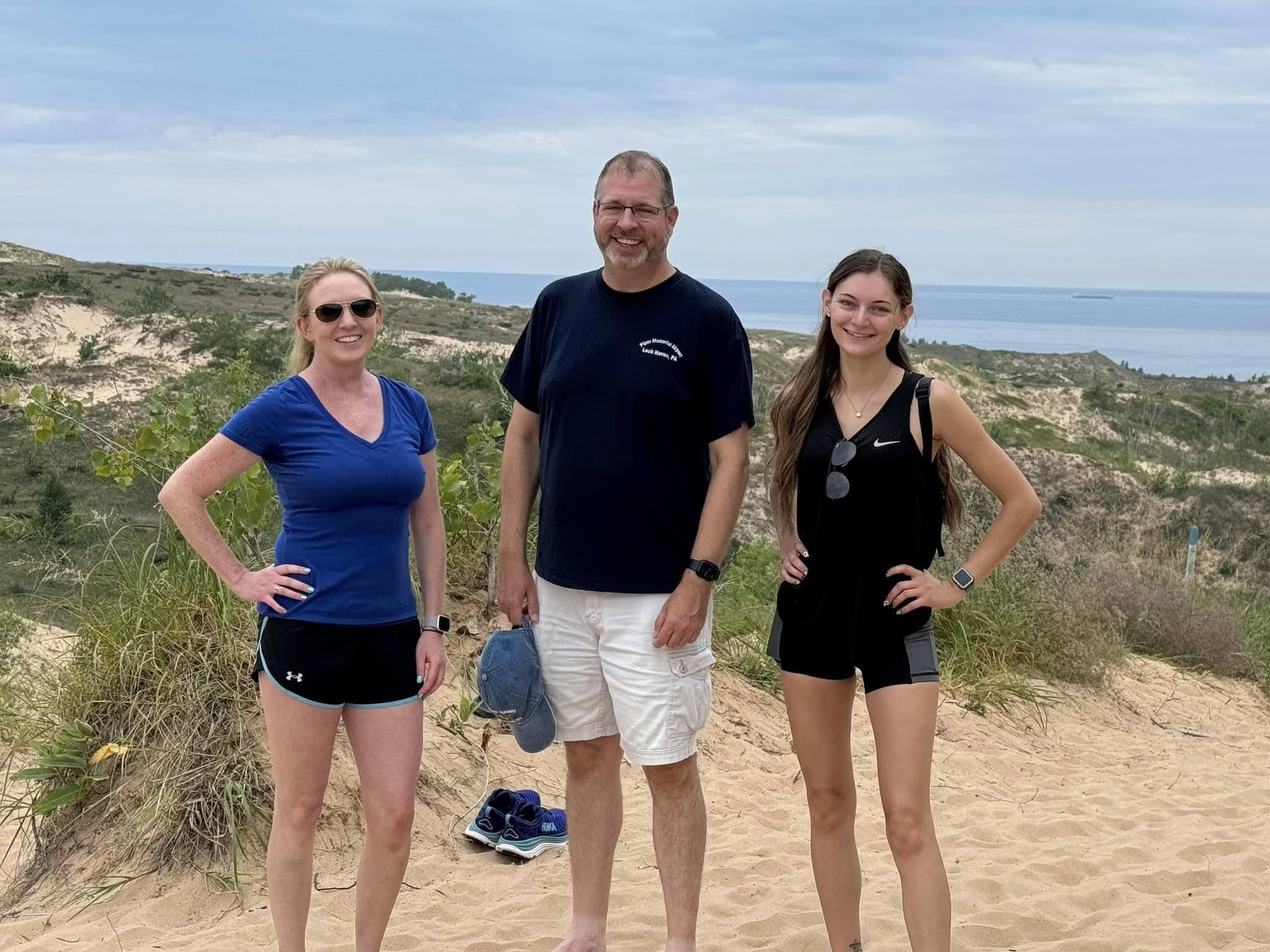
From the visitor's center, we went directly to the Dune Climb, which is the portion of the park where climbing the dunes is actively encouraged. As we stood at the base of the dune, I cautioned everyone that it was taller than it looked and that the apparent top is merely a place where the dune continues upward at a reduced slope.

 |
| Alicia, Alyssa, Tom and me. |
With that warning in place, our crew was good to climb! There's something about climbing the dunes that brings out the child in everyone. Especially in those of us for whom that inner child is pretty darn close to the surface.
 |
| Photo by Alyssa. |
Alyssa managed to capture the exact moment when Tom and Alicia truly realized what we had undertaken. Climbing the sand dune barefoot meant that even our toes received a workout.
 |
| Photo by Alicia. |
We were very pleased with ourselves for gaining some elevation, but we had a long way to go. Though we did not have a pretty blue sky to contrast with the sand, the lack of direct sun undoubtedly made for a more comfortable hike over the dune.

Eventually, we climbed high enough to see Glen Lake over the trees to the east. Glen Lake is an inland lake on the back side of the dunes. Hiking westward across the dune would take us closer to Lake Michigan.
 |
| Looking east toward Glen Lake. |
We continued westbound toward Lake Michigan with a general goal of hiking far enough to see the Manitou Islands.

Looking westbound, the dune continued to rise. As we cleared each rise, I half expected to encounter bands of Tusken Raiders riding their banthas in single file to hide their numbers.


Looking behind us revealed clues about how much elevation gain we had achieved.


Eventually, the vast waters of Lake Michigan came into view and, low on the horizon, the natural memorials to those ill-fated bear cubs of legend: South and North Manitou Islands.
 |
| Alyssa peers out across Lake Michigan. Photo by Alicia. |
 |
| Self-satisfied dune climbers. Photo by Tom. |
We did it! After admiring the view over Lake Michigan, we backtracked to the car. Strangely, despite the exertion of hiking through the sand, my Apple watch never registered that I was exercising until we were on the way back and walking mostly downhill. Curiously, Tom's watch prompted "Are you exercising?" within seconds of mine. We wondered if the exercise trigger had a velocity component that did not register during the slower uphill (updune?) climb.
Pierce Stocking Is Not Some Kind of Footwear
From the Dune Climb, we next tackled the Pierce Stocking Scenic Drive.
 |
| Glen Lake from the Pierce Stocking Scenic Drive. |
The scenic drive is dotted with points of interest. Highlights include forested overlooks of Glen Lake...

... and an overlook of the dune area we had just hiked with the Manitou Islands visible beyond.
But the undisputed highlight of the scenic drive was the Lake Michigan Overlook. This location delivers visitors to the top of the highest portion of the dune characterized by a steep, 400 foot descent to the surface of Lake Michigan. As during my last visit, we saw signage discouraging people from attempting the climb down to the water. Back in 2012, signs indicated that anyone requiring rescue would be billed for those services. Twelve years later, the signage has become even more blunt:

WARNING
Avoid getting stuck at the bottom!
Lake levels are high -- the only way out is up
Rescues cost $3000
Keep yourself and our rescuers out of danger.
Alyssa and Tom performed a useful public service to Sleeping Bear Dunes visitors by visually reinterpreting the signage for everyone.

Despite these warnings, enough people continue to make the climb that a groove has been worn in the dune. Even Alyssa, the biggest daredevil in our group, noped out of that climb as she pondered the steep descent to Lake Michigan.
 |
| Alicia and Tom at the Lake Michigan overlook. Photo by Tom. |

Here, we captured a shot of the WFC atop the highest point in the dunes. We may no longer be the Williamson Fudgie Cyclists, but I guess our decision to stay at the top of the overlook means that we cannot call ourselves the Williamson Fearless Climbers, either.

Shortly after I took this picture, the woman seen climbing on all fours collapsed exhausted on the sand and loudly proclaimed a PSA of her own: that it took her two hours to make the climb.


This picture gives a sense of how steep the descent to Lake Michigan actually is. It is steep enough that most people climbing back up were on all fours and, because they were climbing in sand, each advancement resulted in at least 50% backslide. Climbers made the trip haltingly while taking a lot of rests.

Those little black dots down at the bottom are people!

From the Lake Michigan Overlook, South Manitou Island was visible on the horizon.
After completing the scenic drive, we found lunch in Glen Arbor at the Western Adventure Grill, which was somewhat mediocre and definitely overpriced, but provided sustenance for the next stage of our adventure.
Empire Bluffs Trail
That morning at the visitor's center, a ranger recommended the Empire Bluffs Trail. Still part of the park, the Empire Bluffs Trail skirts the top of a dune overlooking Lake Michigan and is located south of where we had already explored.

The initial portion of the trail is densely wooded, but occasional scenic overlooks allowed us to see the edge of the dune that we visited immediately before lunch.

Someone had obviously done a lot of work to clean up this cool looking root ball.

So, naturally, we had to take a goofy picture with it. (We celebrate weirdness, remember?)


Closer to Lake Michigan, the trail transitioned to a boardwalk. While this may have stabilized the walking path, loose sand on wood made for a slippery surface wherever the boardwalk was inclined.

Emerging from the forest, the Empire Bluffs Trail runs along the edge of the cliff overlooking Lake Michigan. It was a beautifully picturesque scene to traverse.
 |
| Lake Michigan. |
 |
| Looking north toward the main dunes. |


Having explored Sleeping Bear Dunes National Lakeshore and finding ourselves in mid-afternoon on a beautiful day, we decided that it was time to do what flying clubs do: fly! We returned to the car and headed for Traverse City and the Cherry Capital Airport.
No comments:
Post a Comment