
Super Cool
Warrior 481's wings and horizontal tail surfaces were sporting a dense array of translucent warts, large beaded droplets of super cooled liquid water that remained fluid despite a hangar temperature significantly below freezing. Minor disruption promoted immediate crystallization, a problem if I wanted to fly the next morning (February 15).
Do they ever issue Airmet Zulus for the insides of hangars?
I elected to mop up as much as I could with clean towels. Though I removed most of the water, an unwelcome side effect of my labor was a lift-destroying icy film left behind on the wings and stabilator. I hoped that the high surface area of the frost and the incredibly dry air would promote rapid sublimation or else flying would be a no-go the next day.
When I returned the next morning, the wings were completely free of ice. I love it when the laws of nature work out in my favor. That is not always the case.
Yin and Yang
| Date | Aircraft | Route of Flight | Time (hrs) | Total (hrs) |
| 15 Feb 2020 | N21481 | SDC (Sodus, NY) - K09 (Piseco, NY) - LKP (Lake Placid, NY) - SLK (Saranac Lake, NY) - SDC | 4.8 | 2081.3 |
Like all eastbound treks, the journey began with an aerial survey of the Lake Ontario shore and Sodus Bay. But my goal for the day was not to fly around my back yard. Instead, I had my sights set on the Adirondack Mountains and hoped to eat lunch in Lake Placid.


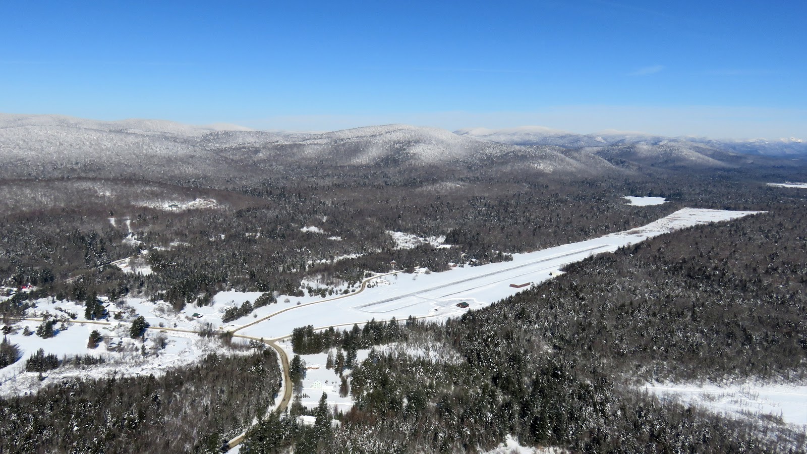
Frontier Field
I planned my first stop at the desolate Piseco Airport for two reasons. For one, I just wanted to land there for fun. More practically, I was hoping to get fuel there because none was unavailable in Lake Placid that morning and I would need more to overcome the inevitable headwind home. Piseco has self serve avgas available for $4.90/gal.

Because Piseco sits in the lee of a large ridge line, GPS direct navigation from the West is not very practical. Instead, I picked up highway NY-8 just east of the Hinckley Reservoir and followed it around the terrain to the south end of Piseco Lake.
 |
| Highway NY-8 winding through frosty evergreens |
It has not been much of a winter in Rochester, but the landscape of the Adirondacks, even the southern Adirondacks near Piseco, was well-frosted.


I rounded the southern end of the ridge line, picked up Piseco Lake, and turned northbound toward the airport. From over the lake, I could see a dark strip of runway indicating that the airport was well-plowed (above). Piseco does not have weather reporting, but nearby airports indicated a southwest wind and my groundspeed certainly suggested that a landing on runway 22 would be most appropriate.

 |
| Piseco Airport |
 |
| Left downwind, runway 22, Piseco Airport |


 |
| Final approach, runway 22, Piseco |
Westerly winds rolling off the nearby ridge often wreak havoc with graceful landings, but not today.

The welcome sign not withstanding, I found Piseco to be deserted (not uncommon), the fuel hose to be completely iced up (disappointing), and three feet of snow drifted against the bathroom door (damn annoying). Plan B was to stop at Adirondack Regional in Saranac Lake for fuel after Lake Placid. Always have a Plan B.


Because of the Warrior's wing dihedral, the wingtips have at least three feet of ground clearance. During taxi at Piseco, the snow surrounding the plowed taxiway was deep enough that I crept along, worried that my wing tips did not have adequate vertical clearance. A better strategy, especially given how deserted the field was, would have been to backtaxi on the much wider runway where edge effects would not have been a factor. Nonetheless, I made it out without any structural damage despite one pile of snow near the end of the taxiway that probably just brushed the bottom of my right wing.
 |
| Climbout from runway 22 at Piseco |
No Man's Land
Geologically, there is very little going on in the geographic center of the Adirondack Mountains. Though the area is ringed by mountains and bounded to the north by the Adirondack High Peaks, the center is comparatively flat, low and kind of boring. It is also desolate. Very, very desolate.

A solitary road runs through no-man's land.


My goal was to fly northbound toward the High Peaks that encircle Lake Placid. A valley between Mount Marcy and Dix Mountain allows passage between the peaks east of town. The valley containing Lake Placid can be entered from the northeast through a notch in the terrain just south of Whiteface Mountain. It was my goal to get some photos of the High Peaks while flying this route near the tops of the mountains.

Flying the Terrain

As I proceeded north, the terrain rose to meet me. The tallest peak at frame right is Mount Marcy. With a 5,344 foot elevation (and a 3,166 foot elevation gain), Mt Marcy is the highest point in New York State.

Similar to flying among the Rocky Mountains, navigation via GPS-direct is useless for this scenario. I followed State Highway 73 north to discover the valley I sought. Upper Au Sable Lake provided a useful landmark for the point of entry.
 |
| View to the east. |
 |
| View to the west. |
 |
| Entering the valley |


Snow billowing from the tops of the High Peaks left little doubt as to the direction of the wind. Aligned with my direction of flight, the airflow hastened my transit of the valley without generating any turbulence. (The turbulence came farther north once I was directly downwind of the peaks.)


This sight was exactly what brought me to the mountains that morning. Mission accomplished.

In the distance, fifth-highest Whiteface Mountain (4,872 foot elevation) came into view.
 |
| Mount Giant. |

Whiteface


South of Whiteface Mountain, I turned southeast toward Lake Placid. I sometimes like to leave airplane bits in the finished photographs to provide a sense of scale.


More airplane bits.

Lake Placid's Big Slide
 |
| Lake Placid |
 |
| The Olympic ice rinks dominate downtown Lake Placid. |
Regardless of the direction I landed at Lake Placid, I was going to have a direct crosswind. I chose runway 14 and touched down in 2" of undisturbed snow. It seems that everyone else was using runway 32 that morning, but I arrived at a quiet moment and did not disrupt anyone's flights.
 |
| Overlay of my GPS track through the mountains on a sectional chart. |
In fact, I was surprised at how quiet the airport was. After I landed, Adirondack Flying Services' yellow sightseeing airplane was loaded up with paying passengers. I waved to them without mentioning that big wallop of turbulence that wracked my airplane as I overflew the airport a few minutes before. Why put them on edge?
 |
| Parked on the ramp at the Lake Placid Airport. |

Airplanes. Mountains. Blue Sky. In my book, a perfect day.

Rather than fuss with Lake Placid's sometimes balky public transportation, I elected to walk a couple of blocks from the airport for lunch at the Big Slide Brewery and Public House. Any place offering an appetizer called "Smells Like Poutine Spirit" has to be good, right?

Honestly, I liked the clever name of the brewery and its reference to Lake Placid's tallest landmark.
 |
| Olympic ski jump towers photographed 15 Jan 2015 |

I decided on the "So Mushroom for Activities" pizza (flatbread crust, herb and garlic base, shredded mozzarella, Dutch Knuckle and pecorino cheese, mixed mushrooms, arugula, balsamic vinegar syrup) and it really hit the spot. My waitress confided that this was her favorite. Maybe I have become too cynical because I always wonder whether these endorsements are actually true.

Back at the Lake Placid Airport, Whiteface Mountain still presided over a largely deserted field.


As I fired up the Warrior, Adirondack Flying Service loaded more passengers for a sightseeing flight.
 |
| Adirondack Flying Service's distinctive yellow Cessna. |
On take-off from runway 32, I noticed my tracks in the snow from landing the opposite direction. I could clearly see where I'd brought the upwind main wheel down first to manage the crosswind, then the downwind main, then the nosegear. I did not even remember thinking about managing the crosswind, but the irrefutable snow record clearly showed that I had gone about it the right way whether I was deliberately conscious of it or not.


The wind increased significantly during my brief stay in Lake Placid and I was bounced around in the climb, which made it difficult to get clear photos of downtown on the way out. I wondered how the sightseeing passengers were enjoying their ride.
Pit Stop
I departed Lake Placid with about 1.5 hours worth of fuel remaining, but calculations showed that the headwind would stretch the return flight home to two hours. Because fuel was unavailable at both Piseco and Lake Placid, Adirondack Regional Airport in Saranac Lake was undeniably best place to fuel up for the return home. Located just 13 nautical miles northwest of Lake Placid, it is mostly a straight shot over low terrain.
 |
| Landing runway 23 at Adirondack Regional Airport. |
Warrior 481 bucked in turbulence as we departed the Lake Placid area. I was not surprised to hear that the wind was gusting into the low 20 knot range when I listened to the automated weather broadcast at Adirondack Regional. Final approach to the 6,600 foot long runway 23 was done at a crawl against the headwind.

As I taxied in to the ramp, I observed some of the additional challenges that snow presented to airports with commercial service in the Adirondacks.
It was a quick turn. The FBO topped off my fuel from the fuel truck ($5.09/gallon) while I chatted with the line crew.
Uneven Balance

I always seem to run at a Karmic disadvantage when it comes to headwinds versus tailwinds. I was happy to accept that morning's 31 knot tailwind en route to the mountains. But on the return flight, my true airspeed (corrected for pressure altitude and temperature) was 120 knots while my groundspeed was only 75 knots, meaning that I faced a 45 knot headwind. It seemed grossly unfair.
I figuratively put my head down against the stiff breeze and trundled home at a rate marginally above where a typical Detroit driver sets their cruise control on I-75.
 |
| Fort Oswego, Oswego, NY. |
Still, at the tail end of a challenging and tiring week, the journey did its job and largely purged the stress that I carried with me into the weekend. It was a particularly good flight with incredible scenery.
I give this one a "star".
Beautiful pics, as always. I really like the ones with the snow blowing off the peaks. The terrain there definitely looks to be no mans land. Do you carry a survival kit on those flights?
ReplyDeleteThat is an excellent question, Gary. The answer is yes, a minimal one, but I'll concede that there's room for improvement. I carry a sleeping bag (which doubles as my cowl cover in the hangar, so it's always available), a fire source, a multitool, boots (because I wear sneakers when I fly), food and water, and a 406 MHz personal locator beacon. Obviously, I always have my cell phone with me, but coverage is poor outside of population centers like Lake Placid or Saranac Lake. Even Piseco lacks coverage.
Delete