
| Date | Aircraft | Route of Flight | Time (hrs) | Total (hrs) |
| 30 May 2008 | PA-28-181 N9908K |
BJC (Denver, CO) - GNY (Granby, CO) - 20V (Kremmling, CO) - LXV (Leadville, CO) - BJC
| 3.6 | 621.3 |
| 31 May 2008 | PA-28-181 N9908K | BJC - SBS (Steamboat Springs, CO) - BJC | 3.4 | 624.7 |
Soaring Tricks in Powered Flight
With an indicated altitude of 13,000 feet, the Piper Archer wallowed in the air, its asphyxiated Lycoming O-360 powerplant struggling, failing, to gain additional altitude. Craggy terrain rose above the toiling aircraft. Directly ahead, a ridge grew to fill the windscreen.
A mere 200 feet from the ridge, it happened. A sensation of buoyancy and, moments later, the vertical speed indicator (VSI) needle twitched and abruptly leapt from an anemic near zero climb rate to an astounding 1600 feet per minute. We rode an upward surge of air as the westerly wind slammed into the sheer rock wall of the ridge. Terrain dropped away from the soaring Archer, revealing a world beyond the stone battlements surrounding Weston Pass. Less than two minutes later, we were level at 15,000 feet.
As the exhilarating moment waned, I came to understand a bit of what it meant to fly in the Rocky Mountains. It was the art - no, the science - of leveraging wind, sun, and stone to make an aircraft perform beyond its capabilities.
Mountains!
Early in 2008, I planned to attend a scientific conference in Denver, CO during the first week of June. This got the wheels turning in my head and I realized that staying in Denver would provide a perfect opportunity to stretch my envelope a little by taking a mountain flying course. Over time, my plans for the conference disintegrated, but I had become so enamored with the idea of learning to fly in the mountains that I went ahead with the vacation anyway.
I searched for flight schools in the Denver area and stumbled across Journeys Aviation at Rocky Mountain Metropolitan Airport. Not only did the website advertise a mountain flying curriculum, but Journeys had a stable of Piper aircraft available to rent. This appealed to me because it meant that I could do the training in a familiar airplane, rather than divide my attention between a new (to me) make of aircraft and mountain flying. With Journeys as my front runner, I called to see if I could do the training in a Piper Archer (a 180 hp version of my Warrior) rather than the recommended Diamond. I was told that most of the instructors would not fly the Archer back in the mountains, but that their most experienced instructor, Reuben, would.
A few more phone calls later and I had reserved four mornings with Reuben for the last week in May. One of the calls was particularly memorable as Reuben animatedly described the convoluted approach to the Glenwood Springs Airport in his distinctive Australian accent. It became very clear to me that Reuben knew his stuff, but was no stodgy CFI. Flying with him was going to be a lot of fun. We planned three flights with the fourth day held in reserve in case weather failed to cooperate. After all, weather almost always fails to cooperate. And it did.
The morning of May 28 began with the airport beacon at Rocky Mountain Metropolitan turning in silent declaration of IFR conditions at the field. The airport sits atop a large hill on the outskirts of Denver and was literally thrust into the diffuse belly of low hanging cloud for much of the morning. Reuben and I used that time for mountain ground school. I was delighted to find that Reuben taught to my learning style. He avoided dogmatic "do this" and "do that" directives in favor of establishing fundamental principles of mountain flying that I could use to think my way through each situation.
A review of winds aloft forecasts and data from automated weather observation facilities throughout the mountains quickly squelched any hopes of flying on May 29. Winds were howling through the passes at speeds that Reuben considered unsafe (or, at best, not conducive to an enjoyable experience). We occupied ourselves that morning with flight planning and reviewing performance data for the Archer I had reserved. To our chagrin, Piper performance charts largely top-out at 8,000 feet. With some extrapolation and conservative overestimation of gross weight, we arrived at some reasonable performance figures. Blind faith in extrapolated numbers is well outside of my comfort zone, but we mitigated this by planning several practical safety checks during the flights. For example, we calculated minimum altitudes for crossing each pass and determined departure abort points on all runways.

Our first good flying day was May 30. We departed Rocky Mountain Metropolitan at 7:20 am. To the west, the so-called Flatirons (pictured above) marked the foothills of the Rockies. Though impressive from the ground, the Flatirons were obviously much smaller than mountains further west.

Though small enough that they barely register on a sectional chart, the Flatirons are striking in appearance. As the Archer clawed its way to higher altitudes, we crossed directly over them. From above, they appeared to be massive plates of stone thrust up on edge through the Earth's crust.

Once clear of the Flatirons, we needed altitude. Our goal was Corona (aka Rollins) Pass, above the Moffat Tunnel. Given the 11,500 foot elevation of the pass, our objective was to cross at 13,000 feet to provide adequate buffer for the inevitable downdraft we would experience from our leeward approach. At these altitudes, the Archer performs rather poorly and we sought thermals to expedite the climb. Once we reached 13,000 feet, we crossed Corona Pass at a 45° angle to the ridge (pictured above). Once across the ridge, we found ourselves in the mountains proper. What struck me most was how smooth the ridgeline was. Mountain flying experts often suggest visualizing wind behavior by imaging how water would flow under the same conditions. The analogy seemed particularly pertinent as I looked at the erosion-smoothed ridge below my wing.
Our first destination was Granby Grand County Airport at an elevation of 8203'. The week before, Reuben had a scary experience at Granby when a student performed a poorly executed go-around. This prompted me to ask what a go-around at high elevation was like, so Reuben had me do one about 20' off the runway surface. Frankly, I think he wanted to do one just to cleanse himself of the previous negative experience. Fortunately, the go-around went quite well. We circled around in the pattern again, made a full stop landing (a total greaser), and we departed westbound for McElroy Field in Kremmling.

Pictured above is the road running from Granby to Kremmling, with the town visible to the far right of frame. I was very surprised by the varied terrain within the Rockies. As we flew among the mountains, we saw more than jagged stone and inhospitable terrain. Rivers, lakes, and green valleys dotted the landscape, providing the alert aviator with many emergency landing sites (some obviously better than others).

After a full stop landing at McElroy (elevation 7411 feet), we turned southeast toward Leadville. Our first visual waypoint was the Green Mountain Reservoir (pictured above) located approximately 10 miles from McElroy Field.

South of Dillon Reservoir, we entered a steep valley. Breckenridge ski resort is somewhere on the other side of the pictured ridge.

We cruised close to the eastern ridgeline to minimize turbulence and leverage the updrafts provided by a westerly airflow.

As we neared Fremont Pass, the Climax molybdenum mine came into view. This mine was once considered the largest supply of molybdenum in the world. Though past its glory days, the manmade cuts into the mountain made for an impressive view.
Arrival in Leadville

Here I am with the iconic mural on the hangar doors of Lake County Airport in Leadville. As the highest elevation airport in the United States (9927 feet above sea level), this airport has reached almost mythic status among pilots. It epitomizes the deleterious impact of high altitude on aircraft performance: less air for the propeller to bite into, less air to support the wings, and the engine virtually suffocates for lack of oxygen. Our departure from Leadville was an eye-opener. At full throttle, the engine made all of the usual noises without any of the usual acceleration. Had it been a much warmer day, the 6400 foot long runway would have been inadequate for a safe departure in Archer Zero Eight Kilo.

My rented steed, N9908K, parked on the ramp at Lake County airport in Leadville. A 1978 Archer II, this airplane flew just like my Warrior with the exception of 20 extra horsepower. With V-speeds within a couple knots of the Warrior, I did not have to learn anything new to fly this airplane properly and my first landing in Zero Eight Kilo was a greaser. It is a well-rigged, solid airplane. After flying no other airplane but Warrior 481 for over four years, I never misidentified Zero Eight Kilo on the radio. Perhaps that's my greatest accomplishment for the entire trip!
Our original plan had been to depart Leadville for Glenwood Springs, a tricky airport on the western side of the Rockies. But during out time on the ground at Leadville, rotor clouds began to appear downwind of the peaks to the west. We decided to defer a trip to Glenwood Springs for the next day and make our way back to Rocky Mountain Metropolitan.
The most exciting part about leaving Leadville was successfully finding ridge lift near Weston Pass. We climbed from 12,000 feet to 15,000 feet with a vertical climb rate of 1500+ feet per minute. This exercise underscored Reuben's assertion that, in order to successfully navigate the mountains, a pilot needs to exploit sources of lift beyond what the airplane provide on its own. The rapid ascent was exhilarating and we quickly cleared the peaks ringing the valley around Leadville.

Day Two: May 31
Our second flight took place on the morning of May 31. Though we had planned to make for Glenwood Springs, we changed our plans owing to poor visibility in that direction. Our backup plan was to fly to Steamboat Springs. En route, we observed this impressive gash in a mountain ridge created by a narrow river; another tribute to what erosion can accomplish on a so-called geological timescale.

Reuben caught this shot of us lined up on final approach for runway 32 at Steamboat Springs (SBS, elevation 6882 feet, 4452 feet long). On the ground, we took a break, planned our next move, paid a ramp fee (much to our annoyance) and met Ted the Airport Cat. Though the ramp fee was not exorbitant, it emptied my wallet of cash and I had to ask Reuben to chip in a couple of bucks.
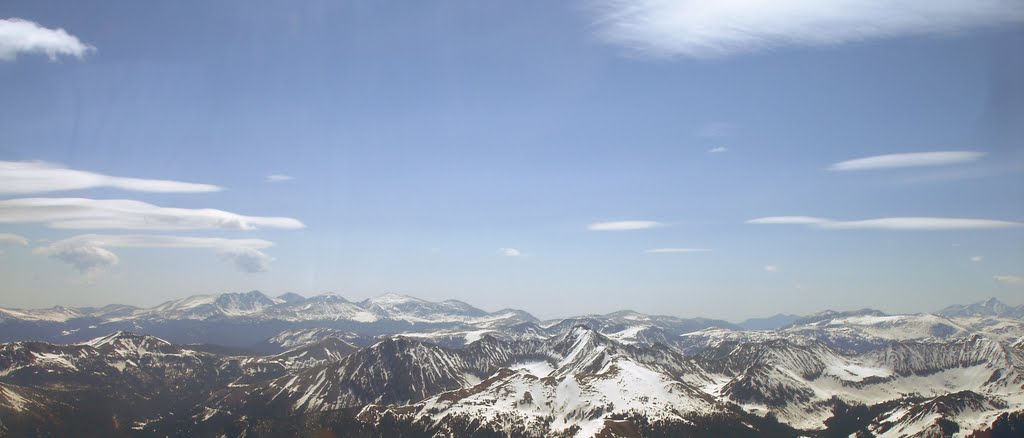
Pictured above is one of nature's ways of saying "Do Not Enter". Looking east, the sky was filled with lenticular clouds indicative of wind shear and potential mountain wave activity. My vote was to turn south, away from the lenticular clouds, and cross back out of the mountains via Corona Pass. Reuben agreed that this was a good idea and so we departed the mountains the same way we had entered that morning.
On the way back through the front range, Reuben asked, "Do you trust me?"
When I affirmed that I did, Reuben pointed to a nearby valley. "I fly through there all the time. There are no obstacles or wires." He had me maneuver for the entrance. Set on massively sloping terrain, the valley floor rapidly fell away from us toward Denver. Reuben instructed me to chase it by pulling the throttle to idle, pitching down, and allowing the airspeed to build to the top of the green arc.
We flashed downward through the valley at a near constant altitude above the descending floor while surrounded by granite walls on both sides. Ahead, the valley made an S-turn. Still in a steep descent, I cranked the Archer over hard to port, then almost immediately back through neutral and into a steep turn to the right. With some additional quick maneuvering, the Archer was spat out of the valley over the Denver suburbs. It was the most aggressively I had ever maneuvered an aircraft and it was utterly exhilarating.
"Well? What did you think?" Reuben queried in his Aussie accent, grinning broadly the whole time. He already knew the answer.
In Summary
In the end, it was an incredible experience. How did I do? I received high marks from Reuben for my ability to navigate from the sectional chart (ah, the dying art of pilotage) and for my near flawless execution of a high-elevation go-around at Granby. He was even complimentary of my landings, though a few of them were more firm than I prefer. Am I suddenly transformed into an experienced mountain pilot? Of course not. But I do think about terrain and altitude a little differently than I did before and that will be helpful for future trips to the Adirondacks or even the "mountains" of Pennsylvania.


