
Oops!
As Warrior 481 climbed aloft in frigid air, I realized that I had left my camera and constant flying companion at home. The goal for the day was visiting an old friend from high school and photography was not my priority. In what was probably the greatest irony of the year (flying wise), I would return home with a truly spectacular set of cell phone photos at day's end.
Stay Out of the Ice
| Date | Aircraft | Route of Flight | Time (hrs) | Total (hrs) |
| 28 Dec 2022 | N21481 | SDC (Sodus, NY) - PTK (Waterford, MI) - SDC | 6.2 | 2575.7 |
I was less worried about photography and more worried about ice that morning. Icing warnings abounded and, while not unusual for the Great lakes region in winter, the expected placement of cloud layers would make those icing warnings a genuine threat. In final planning, cloud and icing forecasts congruently suggested that I could make my way to eastern Michigan between layers at 6,000 feet without passing through any clouds. With that understanding, I decided that the flight was a "go".
My second concern of the morning was headwind, predicted to be as high as 40 knots directly on the nose of the airplane. Fortunately, I had plenty of gas on board despite failure of the fuel farm at the Williamson Sodus Airport. I received that news the day before departure and made a special trip in Warrior 481 to a nearby airport to top off the tanks. I attempted going to Canandaigua (KIUA) where the fuel appeared to be cheapest in the area, but was blocked by a snow squall and instead flew to Fuzzy (KFZY, Oswego County Airport).
In reality, both forecasts turned out to be incorrect. Clouds were much less restrictive than expected and the maximum headwind I experienced was 51 knots, not 40. It was an easier, safer, but slower flight to Michigan than anticipated.
Despite the massive headwind, I had five hours of fuel on board, plenty of music to stay entertained, and what would turn out to be some impressive scenery over Canada to hold my interest.
Brief Dawn
 |
| Just west of the Williamson Sodus Airport, already on course for Pontiac. |
Dawn was brief that morning, defined by the sun’s rapid transit of the breach between horizon and overcast. Warrior 481 climbed quickly in the dense air and, despite cloud layers above and occasionally below, the view from 6,000 feet was as clear as suggested by the forecast. I proceeded westbound on an IFR clearance with confidence that I could reach Michigan safely.
Seeing this unusual sunrise within minutes of departing Sodus immediately made me regret leaving my camera at home. Fortunately, I had the iPhone with me to capture pictures for this post. All photos presented here are unadjusted except for cropping and rotating. Colors processed by this svelte cell phone camera are nothing short of stunning, but are nonetheless a faithful reflection of nature.
 |
| Looking south over western New York in the gloomy dawn. |
 |
| View from the front office, proceeding westbound toward Canada. |
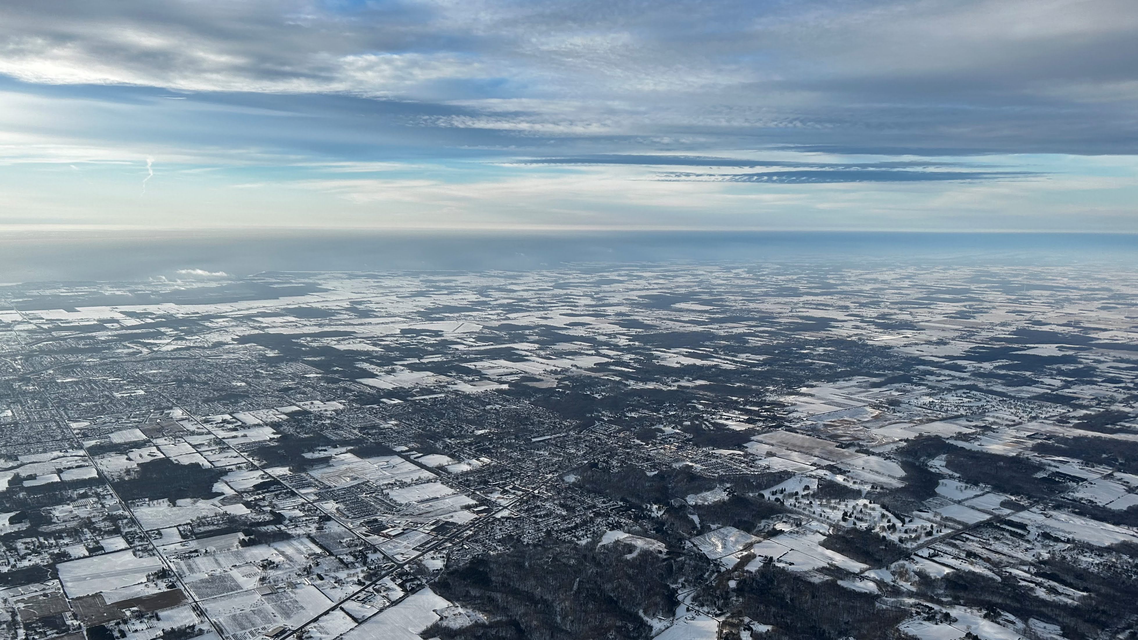
At altitude over Rochester, I was already affected by the wind. With a calculated headwind of 39 knots, the airplane crawled across the ground at 84 knots (97 mph). Forecasts suggested that this wind would increase as I continued westward. I departed Sodus at 7:30 am and expected to arrive at Oakland Country International by 11:30 am.
 |
| Fields north of Batavia, NY. |

As I proceeded westward, the overcast began to break up.

Buffalo looked remarkably peaceful below, despite the previous weekend's Christmas storm that dropped 51 inches of snow on the city, claimed at least 39 lives (as of this writing), and essentially shut everything down.
Niagara Falls in Pewter
 |
| Niagara Falls. |
 |
| Niagara Falls. |

On cold mornings, water tumbling from the Niagara escarpment usually produces a massive plume of mist that climbs skyward. Instead, this morning's mist crawled eerily along the surface of the river in a manner that cannot be captured by a still image.
Canadian Passage
 |
| With the Niagara River just behind the airplane. |
Buffalo handed me off to Toronto Center a few miles before I crossed the Niagara River. Above Ontario, I saw my first hints of blue sky. This was in utter contrast to a forecast that caused me to expect encapsulation between cloud layers for most of the Canadian passage.
 |
| Looking northwest across Lake Ontario toward Toronto. |
Several times along the way, the sky took on the appearance of an artist's watercolor creation.
 |
| Objective evidence of the headwind and resulting mediocre ground speed (GS). |
I encountered the strongest headwind near Hamilton, Ontario. Plowing forward into 51 knots of wind, ground speed was depressed as low as 73 knots (84 mph). Knowing how people drive near Hamilton, cars on the QEW may have been outpacing me. Nonetheless, the slow flight still beat driving (in time and comfort) and I calculated that I would arrive on time with at least an hour of reserve fuel in the tanks. With HAL at the helm, I sat back and enjoyed the dramatic world outside my windows, grateful that I was not caught in the dense traffic below.
 |
| Just west of the Welland Canal, Ontario, Canada. |

Nearing Hamilton and the west end of Lake Ontario, the overcast disintegrated in earnest.
 |
| Sunlight reflecting off of Lake Erie. |
 |
| Ontario, Canada with Lake Erie in the distance. |

Snow streaked across the farmland explicitly memorialized the wind direction of the last storm to sweep through the area, a "bomb cyclone" created by an extremely deep low pressure system. It was the same weather phenomenon responsible for crippling Buffalo.
 |
| Tillsonburg Regional Airport, where I once contemplated an emergency landing. |
There was minimal air traffic over Ontario and I flew in utter silence for an extended period of time. I hand flew for a while over Canada, but the air at altitude was so calm that I quickly became bored and reactivated HAL.

Crossing the St Clair River into Michigan, a haze layer made it difficult to acquire the destination airport visually, but I still found it from 20 miles out. Despite a smooth flight at 6,000 feet against a westerly atmospheric flow, the surface wind at Pontiac was a direct crosswind from the south of 8 knots gusting to 20. The shear layer through which this change in wind speed and direction occurred was quite turbulent as I wrestled the Warrior along the RNAV-27L instrument approach by hand.
Haunting the Old Haunts
After being thanked by the Pontiac ground controller for accepting a goofy taxi route to Michigan Aviation that accommodated some other ground movements, I arrived on the FBO ramp without anyone to marshal me to parking. After idling a few minutes at the edge of the ramp, I parked in the usual place. After shutting down, a couple of line crew members walked past without acknowledging me.
Disembarking from the Warrior, I caught one of them as he walked by and I asked if my parking place was appropriate. He looked annoyed, shrugged, and said, "Sure."
Welcome home.
It was a far cry from the days of Scott greeting me by name. I miss Scott.
 |
| Mike, photographed in 2021 during the WFC visit to Detroit. |
Mike was waiting in the parking lot and we set off to Clarkston for lunch.
 |
| The Clarkston Union's "Macmobile". |
We found it at the Clarkston Union, renowned for its "most macked mac 'n' cheese" that was once featured on Diners, Drive-Ins, and Dives. My last meal there was with my mother before she passed away. The bar and restaurant came to life in a derelict Baptist church on Clarkston's Main Street when I was a graduate student in the 1990s. Locals absolutely lost their minds over the proposal to transform the decrepit church into a bar. Despite all the panicked hand wringing it garnered in 1995, the Union has become a well-loved and frequented establishment in the heart of town. Inside, former pews are used to seat diners and the old bingo board is still up on the wall for ambiance, right next to an extensive chalkboard beer list. Mike and I arrived a few minutes before opening and joined a line to get inside. The place filled to capacity not long after we were seated.
 |
| Hey, if it's good enough for Guy Fieri... |
Clarkston Union's mac and cheese is quite delicious, but very rich and I do not always have the fortitude required to eat it. But I did on this day.
After getting caught up over lunch, Mike and I did some shopping for a close friend going through very challenging times. By 2:45, Mike returned me to Oakland County International.
Wednesday's [Route] is Full of Woe
At Michigan Aviation, the Warrior was already fueled and ready to go. With my credit card on file, the account was settled before I returned.
I filed a flight plan using my preferred ADRIE route that avoids the typically-assigned HHOWE departure procedure. The problem with the HHOWE departure is that it requires an extended flight down the middle of Lake Erie's long axis. I remembered to include a note in the flight plan requesting no routing over Lake Erie. Even though the FAA computer always assigns this route, a flight plan remark will usually cause a controller at Pontiac to intervene. For the first time in years, that ploy was of no avail.
"Cherokee Four Eight One, it's going to be a full-route clearance..." and Pontiac Ground proceeded to assign me the HHOWE route (HHOWE DKK WOZEE) across Lake Erie.
#&@$!
To add insult to injury, the southeast heading required by that route would subject me to a partial headwind for the first half of the flight, adding 20 minutes to the flight time versus the route I filed.

I was given "line up and wait" on 27-left where I sat for a few minutes while a recently arrived business jet rolled to the end of the 6500' runway before clearing. On take off, wind forcefully shoved the Warrior to the north immediately on breaking ground.
Having trained at an uncontrolled field where I was taught to crab into the wind to track directly over the physical runway, it requires discipline for me to turn the airplane onto runway heading and allow myself to be pushed laterally away from the pavement. "Fly runway heading," reminded Tower as I broke ground, as though privy to my internal dialogue.
 |
| Otter, Sylvan and Cass Lakes in Oakland County, MI southeast of Oakland County International. |
Detroit Approach vectored me through their Bravo airspace toward the HHOWE waypoint over Ontario, stepping my altitude up in 1000 foot increments as I put more distance between myself and KDTW. Approach was busy and I decided to wait for the handoff to Selfridge before requesting a change in routing.
 |
| Looking due east along the I-94 corridor north of downtown Detroit with Lake St Clair in the distance. |

High rises in downtown Detroit were silhouetted against the Detroit River as I exited the area to the southeast. Sunlight reflecting from the surface of the distinct haze layer made it difficult to see the skyline in detail.
In the climb, I noticed that the oil temperature was running hotter than usual. (Still in the green, but hot). It was due to a temperature inversion that existed over Detroit where the outside air temperature was approaching 50°F at my altitude, warm for operation with the oil cooler winterization plate installed.

I crossed the Canadian border over the south end of frozen Lake St Clair (above) and Detroit passed me to Selfridge Approach. The military controller was much less busy and happy to help when I requested a route that did not require flying across Lake Erie.
"Let's see what they gave you... Would direct to your destination work?"
Not only would it work, but it would put the tailwind directly aft of the airplane to speed me home sooner. I accepted. After some coordination with Cleveland Center, Selfridge turned me toward home on a route that would keep me within gliding distance of the northern Lake Erie shore

Initially turned to a 080° heading, I recorded my highest groundspeed for the day: 165 knots (190 mph). Because the wind diminished over the course of the day, the magnitude of tailwind carrying me home was less than the headwind I faced that morning. Still, the differential between my lowest and highest speeds across the ground that day was 92 knots (106 mph).
 |
| East shore of Lake St Clair and Ontario farmland. The warmth of the day melted most of the snow. |
Blaze of Glory

Looking aft of my ship, it was evident that a spectacular sunset was in the works.
 |
| Flying just offshore along the north side of Lake Erie. |

 |
| Ice on the inner portion of Long Point Bay. |

 |
| The Welland Canal from over Port Colborne with Lake Ontario in the distance. |
 |
| Sunset over Lake Erie. |
 |
| Buffalo and the mouth of the Niagara River from 7,000 feet. |

 |
| Warrior 481's instrument panel while flying over Buffalo. |
 |
| Watercolor brush strokes in the clouds over Lake Ontario. |

As the sun burned its way toward the horizon at my tail, the pink band of the antitwilight arch manifested above the eastern horizon.

As I flew between Buffalo and Rochester, the sun descended through an altitude allowing it to enflame the cloud bases.
 |
| Clouds over Lake Ontario to the north. |

 |
| No filter, no tweaks. This is a raw image from my iPhone that has only been cropped. |
 |
| Rochester, NY at dusk with downtown in the lower left of frame. |
 |
| The NY-104 corridor and Irondequoit Bay. |
 |
| Setting sun over downtown Rochester, NY. |
 |
| Left base for runway 28 at the Williamson Sodus Airport (lit up right of frame). |
Despite a significant change in wind velocity throughout the descent, the windspeed gradient was smooth and so was the ride.
 |
| Final approach, runway 28, Williamson Sodus Airport. |
Tall trees have grown up just south of the final approach course to runway 28 and have caused me to routinely fly an angled approach to avoid them at night.

After a smooth landing, I parked outside my hangar and tidied up the airplane cabin as the western horizon continued to blaze. I had just flown from my home town to Sodus in under two hours, making a true airspeed of 120 knots with a 7.6 gallon/hour fuel burn! For all of the planning and angst that I put into preparing for the flight to see Mike, it was actually an easy flying day that delivered some spectacular visual rewards.
Best wishes to all for a wonderful 2023!
No comments:
Post a Comment