Friday, December 31, 2010

Encounter with a World Traveler

Date Aircraft Route of Flight Time (hrs) Total (hrs)
31 Dec 2010 N21481 5G0 (LeRoy, NY) - N23 (Sidney, NY) -
OIC (Norwich, NY) - 5G0
2.8 893.0

On the last day of 2010, I went exploring.  I crawled away from Le Roy under a low overcast, finally emerging in clear skies east of Rochester.  My first destination was Sidney NY, a small airport surrounded by high hills.  I parked at the full service fuel pump ($4.26/gal) nose to nose with a very nice looking Mooney.

As the line guy fueled my aircraft, another gentleman approached and offered to help move the Mooney, if needed.  Seeing that the Mooney did not need to be moved, he gestured toward Warrior 481.

"Nice looking airplane!" he said.

"Thanks," I smiled back at him. "But it's no Mooney." I indicated the airplane I surmised to be his.

"Oh, I'm just a passenger. The Mooney belongs to a friend of mine. Nice airplane, though. Fuel efficient." We made some more small talk about how I was out exploring new airports that morning and he was en route to New Jersey for a $100 hamburger with the pilot of the Mooney.

"This Mooney is a world traveler," he boasted. At my impressed expression, he quickly clarified that it was the former owner of the airplane who had flown it solo around the world. "There's a great website written by the guy who did it. You should check it out."

I captured a snapshot of the airplane with my cell phone so that I would not forget the tail number (yeah, this photo doesn't really meet my usual aesthetic standards, but a legible tail number was all I really needed).


The rest of the unseasonably warm day passed with the exploration of another airport (completely deserted), return to Le Roy, and an oil change for Warrior 481. That evening, I found the website describing N60RP's journey around the world. It's a fantastic read (no pun actually intended) - I highly recommend it:

"Reed Flies Around the World"

Happy New Year!

Friday, December 24, 2010

Reflection: 2010

With 2010 rapidly dwindling, the shortest day of the year already past, and the near term weather forecast dreary at best, it seems a good time to reflect on flying in 2010.  So, here are some of my favorite images from 2010 along with some numbers.


I flew a total of 108.8 hours at the controls of N21481 in 2010, pictured above on the ground at Luray Caverns Airport in Luray, VA.


I logged 4.2 hours at night, not bad considering that I don't usually stray far from home after dark.


Kristy and The Bear flew a total of 39.7 hours with me this year.  I cannot put into words how delighted I am to share my passion with my family.


I had the good fortune to fly with several non-aviators, sharing a new perspective on the mundane (like I-90, above).  I gave airplane rides to 14 non-pilots this year, including several kids. It was a first time in a light aircraft for most of them.  My flight with Nick was particularly memorable.  Also memorable was a public relations flight on behalf of the Le Roy Airport with the gentleman living below the approach path to runway 28.  The goal was to promote understanding of why our airplanes fly the pattern they do.  It was a successful flight that made us mutually sensitive to each other's needs.


As this image of a Piper Cub landing at Penn Yan shows, there is something magical about bringing an aircraft gently to Earth.  I made landings at airports in Connecticut, Kentucky, Michigan, New Hampshire, New York, Ohio, Pennsylvania, Tennessee, Vermont, Virginia, and West Virginia in 2010.


In 2010, a total 67.7 hours were logged flying to airports more than 50 nautical miles away from home (i.e., "cross country").  This is a picture of the St Clair River, the international border between Michigan and Ontario.


We tried a few new (to us) $100 hamburger locations in our travels including The Kitty Hawk Cafe in Altoona, PA (above), the Cloud 9 Cafe in Prestonburg, KY, and the Plane Bagel (punny!) in Rutland, VT.  Two thumbs up for all three!


I re-affirmed my love for the mountains. These were photographed while flying over Vermont, first in the afternoon, then in the evening haze.


I was able to behold the whimsy of mankind enveloped by the unstoppable force of nature.


At times, I found myself flying through seemingly otherworldly places.


Some trips aloft remained close to home (above, Irondequoit Bay) and were flown strictly for the sake of flying.


Not all of my 2010 aeronautical experiences were at the controls of an airplane.  The Greatest Show on Turf this year was spectacular.


Fog seemed to play a recurrent role in images from 2010.


I had an unusual number of sunset flights in 2010.

In the end, whether it was beauty above...


...the stately works of mankind below (downtown Rochester, NY)...


...or the simple elegance of a winter landscape, my memory is filled with some wonderful images from 2010.

Thanks for visiting, see you next year.

Sunday, November 14, 2010

"It's Always Sunny in Philadelphia"*

* With apologies to the creators of the TV show with the same name.

Date Aircraft Route of Flight Time (hrs) Total 
(hrs)
14
  Nov 2010
N21481
LOM (Blue Bell, PA) - D38 (Canandaigua, NY)
2.5 887.8
15
  Nov 2010
N21481 D38 - 5G0 0.5 888.3

Deceptive Sunshine

It was a beautiful mid-November day in Blue Bell, Pennsylvania, a northern suburb of Philadelphia.  Despite the breeze, a warm sun unfettered by clouds raised ambient temperatures right to borderline "jacket weather".  I was sitting in Warrior 481 at historic Wings Field after spending a few hours in the eclectic company of two scientists and a rock star.  I watched the activity on the runway as I spoke with a weather briefer about my journey home to Le Roy, NY.

The Pennsylvania portion of my two hour flight looked to be ideal VFR weather.  As he reached the New York segment, the briefer hesitated and confessed that the forecasts were changing rapidly and it was difficult for him to provide definitive guidance.  Rain and low ceilings were moving in from the west.  Buffalo weather was downright crummy and Bradford Pennsylvania, which I consider the southwestern extremity of my local area (i.e., a 45 minute flight radius from Le Roy), was already IFR.  These facts gave me pause.

"If you depart immediately and actually make it back within two hours, you'll probably be fine.  But you should check the weather again when you reach the New York border, especially if you are VFR only."

I thanked him for the warnings.  As I have noted in the past, VFR flying is all about flexibility and I am under no illusions to the contrary.  I could always divert somewhere along the way.  Still, it was difficult to be concerned when everything around me was bathed in warm sunshine.

En route at 6500', I had a tailwind that would help me arrive ahead of my original estimate.  North of Williamsport, high clouds to the west finally blocked the evening sun and I removed my sunglasses.  Closer to the border, Elmira was calling a 6000' ceiling and I descended to 4500'.

The briefer was right, the border region was a good place to reassess the weather.  Visibility had fallen from unlimited to about eight miles.  Hazy shafts of rain showers could be seen scattered around my position.  The outside air temperature was about 5°C, removing the threat of freezing rain.  I watched the outside air temperature gauge carefully for the remainder of the flight, thankful that I had a more reliable sensor installed a few months previous.

Although convective activity was lacking in the forecast, the clouds nevertheless looked menacing; the world was draped with a ceiling of charcoal bunting and the cloud bases seemed to be curled into fists poised over my little aluminum airplane.

I passed five miles west of Elmira when light rain first spattered the windshield.  Nonetheless, I had adequate ceiling and visibility to see the airport in the gathering darkness.  Elmira  would be a safe haven if the path ahead worsened.  With this harbor identified, a stake in the ground, I pressed forward.

A few minutes later, the world around me seemed to expand.  I was still beneath an overcast, but there were no more nearby rain showers and visibility increased to at least fifteen miles based on the landmarks I could see.

When I listened to the Dansville automated weather broadcast and heard that visibility was 10+ miles under a 5000' ceiling, I was sure that I was going to make it home.  I could see the runway lights at Dansville and, in the distance, lights from Rochester.  Then I listened to the automated weather at the Genesee County airport, just 11 nautical miles west of Le Roy.

Visibility was 4 miles in rain with a 600 foot ceiling.  Translation: IFR.

The Rochester ATIS, updated hourly, still reported 3500' ceilings with excellent visibility in light rain.  Very manageable, but the broadcast was 40 minutes old.  And somewhere between these two places was home base

Over Dansville, I hesitated.  The weather at Le Roy could be fine...or not.  Dansville would be a suitable diversion point, but it would be nice to get closer to Rochester in case I needed to leave the airplane someplace.  I checked the weather at Canandaigua, verified that it was good VFR (10+ miles, no precip., 8500' ceiling), and turned in that direction.


On the ground at Canandaigua, I took a moment to regroup.  Then, I used my cell phone to call the Rochester ASOS to obtain a current weather report.  Conditions were still VFR at Rochester and above my personal minimums.  With another phone call I verified that it was still IFR at Genesee County.  From my conversation with the briefer earlier in the day, I knew that the cold front and its associated clag would be moving east.  With Le Roy between the only two weather reporting points available to me, actual conditions at my home field were a complete unknown.  It all depended on how far east the front had progressed.

I decided to depart Canandaigua and fly west at 3000' toward Le Roy.  If I ran into any reduced visibility, even a hint of it, I would return to Canandaigua.  While I enjoy flying at night, my nighttime preferences are clear skies, moonlight, and familiar (preferably flat) terrain.  The notion of blundering into a cloud at night is, frankly, terrifying to me.  I did not want to become a "continued VFR flight into instrument conditions" statistic.

A dark night enveloped Canandaigua.  The sun had finished setting and the clouds to the west effectively cut-off any residual twilight that might have otherwise lit the sky.  A constellation of ground lights twinkled below, dimly illuminating the ceiling in a manner that compensated for the lack of horizon.


Aloft, I inched toward home.

I crossed I-390, due south of Rochester.  Nine miles to go.  So close...

Then, I noted a slight blurring of lights in the distance.  I was not in a cloud, but there was definitely an obscuration between me and Le Roy.  Given the dark night, I had no desire to press my luck any further.  I executed a standard rate 180° turn back to Canandaigua.

The ramp at Canandaigua was extremely dark.  I tied Warrior 481 down and fastened the cabin cover around the fuselage.  My only light was the occasional sweep from the airfield beacon and a flashlight clipped to my belt.  Rain started falling as I finished.
  

During this effort, a locally-based Cessna landed and parked directly behind Warrior 481.  Pilot and companions spilled from the cockpit, laughing jovially, as they pushed the Cessna into a T-hangar.  Before long, the bifold door closed, everyone jumped into an SUV, and I was alone again on the ramp.  Though I did not need help and Kristy was already on her way to pick me up, I was stunned that anyone would see an unknown aircraft and pilot at their airport after dark, in light rain, and not bother to check if they were in distress.  Had I seen such a thing at Le Roy, I would have checked.

I discovered that the terminal building was unlocked and sought refuge from the damp.  I sent a email to my friends at Le Roy letting them know I had diverted to Canandaigua in case the sight of my car still at the airport alarmed any of them.  I was surprised not to receive any replies.

The Day After

By the next day, Monday, the nasty weather had moved out of the area.  I wanted to ferry the airplane home as soon as possible because (1) my car was still in Le Roy and (2) temperatures were still relatively warm and I wanted to move the airplane before cold starts could become an issue.

My good friend Stacey, a recipient of many airplane rides over the years, volunteered to drive me down to Canandaigua after work on Monday night.  The weather was perfect for a night flight, with clear skies and a bright moon looking down on the Rochester area.  Stacey and I had stopped for sandwiches before the trek southeast when I received a call from Ray at Le Roy.

Though my friends did not respond to my email note, they began working (scheming?) independently on a plan to get my airplane home.  Ray explained that Darrell was already in the air and willing to pick me up at the Williamson-Sodus airport (the closest airport to my house) to shuttle me to Canandaigua.  This would mean much less driving for Stacey.  I agreed to their offer for help and listened through the phone as Ray firmed up our plans with Darrell via Unicom.

About forty minutes later, I was riding in Darrell's Cessna for the first time.  It was a magnificent night to fly.  The sodium vapor lights lining Rochester's streets and highways gave the appearance of a massive golden spider sprawled across the landscape.

At Canandaigua, Darrell parked directly in front of Warrior 481 and surveyed the ramp.  "This IS a dark ramp," he agreed.  When we illuminated Warrior 481 with our flashlights, I caught my breath.  The wing surfaces looked rough and what appeared to be large, transparent warts were scattered across them.  Frost and ice would be a non-starter for this flight.  With a brush of my hand, I learned that it was all just condensation, with the warts simply being larger droplets of water beaded on the wax.

Because the Warrior was out all night in the rain, I was particularly careful to examine the sumped fuel for moisture.  There was none.  When ready to go, I climbed into the cold, dark cockpit and swept my hands over the familiar controls.  I'm sorry I abandoned you here last night, but it was the right thing to do, I thought to the airplane.

I ran the pre-flight checklist, gave four shots of prime, and the engine fired immediately.  Darrell led the way to the departure end of the runway.

The flight home bore a striking resemblance to the one from the previous evening with the exception of the visible moon.  When I reached I-390, my turning point from the night before, the ground lighting in the distance remained as crisp as ever.  Ahead of me, strobe lights marked the passage of Darrell's Cessna through the nighttime sky.

I landed lightly on Warrior 481's main gear after Darrell cleared the runway.  "It doesn't get any better than that," I shared with him over the radio.

Debrief

I do a reasonable amount of VFR flying outside my local area, sometimes across multiple states.  In nearly 900 hours, I have never needed to divert because of weather, though I have grounded myself plenty of times when I had planned to be flying.  I would like to think that this prudent go/no-go decision making is responsible for my track record.  And, ok, maybe a little luck too.

So what did I learn?  Nine miles (less than five minutes) from home is a tempting target in an airplane.  I learned that I can set a limit for myself ("I'm going to fly at 3000' and turn around at the first sign of reduced visibility") and abide by it in the face of "get-there-itis" and close proximity to home.

I also learned that I have some truly excellent friends.  Many thanks to Stacey, Ray, and Darrell for their enthusiastic and unsolicited help.  And, of course, thanks to Kristy for driving down to Canandaigua...in the rain...while sick...and not complaining once.

Thursday, November 11, 2010

Spam Can or Monster Truck?

Date Aircraft Route of Flight Time (hrs) Total 
(hrs)
11
Nov 2010
N21481 5G0 (LeRoy, NY) - FZY (Fulton, NY) - 5G0 1.9 882.7

Friday night, I flew along the shoreline of Lake Ontario for a little relaxation.  I had no objective, no desire to explore new places, or any urge to push my abilities.  I wanted to cruise.


The shoreline of Lake Ontario with a steam plume from the nuclear power plant in Oswego visible, two of the best visual waypoints ever.


I landed at the Oswego County Airport in Fulton, refueled, and taxied for departure as the sun began to set.  Though the sunlight seemed to enflame the field between the taxiway and the runway, what caught my attention was my shadow.  Warrior 481, what big wheels ya got!  Perhaps my new handle should be "Bigfoot"?

 
Flying home, I was pointed directly into the setting sun.  Such poor planning.


To my one-o-clock, some lights from Rochester suburbs were visible and the few clouds in the sky were bathed in the warm glow of a sun that had already retreated beyond the horizon.


 Darker.


Darker still.  I soared through still air that is so often a companion of twilight.  A good night to fly.

Saturday, October 23, 2010

Grass Roots

Date Aircraft Route of Flight Time (hrs) Total 
(hrs)
23
  Oct 2010
N21481 5G0 (LeRoy, NY) - N38 (Wellsboro, PA - DSV (Dansville, NY) - 5G0 2.1 879.4

Airports come in many flavors.  Say "airport" to the average citizen and they will no doubt conjure a mental image of heavies launching from the vast asphalt maze that is Chicago O'Hare or John F Kennedy International.  In truth, airports cover a continuum from the world's busiest commercial hubs to sleepy rural airfields that see very little activity.  In a world where smaller airports are threatened by economics and public opinion, some places still harbor an unquenchable spark of life where "grass roots" flying still exists.  Pilots are drawn to these places.  One such pocket is the Wellsboro-Johnston Airport (N38) in Pennsylvania where the grass roots spirit lives within manager Wes McKinney.  Pilots don't come much more "grass roots" than Wes.  If asked, he'll proudly tell you that he's not qualified to even land on pavement.


The most brilliant of fall colors were retired for the season when I arrived over the impressive hills of northern Pennsylvania's "Grand Canyon".  Reds and yellows still dominated the landscape, but the color saturation was a bit "lean of peak".

 
On the ground at Wellsboro, I was met by manager Wes and his four-legged assistant managers Pratt and Whitney.  I gave Pratt (or was it Whitney?) a scratch behind the ears as Wes introduced Jerry.  Wes was doing some electrical work on Jerry's airplane so, in return, Jerry was acting in the capacity of line boy for the day.  Under Wes' tutelage, Jerry set up the fuel pump for me, stopping short of actually pumping the gas.

"THAT," Wes explained with a grin, "would cost me an extra two cents per gallon in liability insurance."

When I asked for an update on his Murphy Moose project, Wes proudly announced that the aircraft had just passed its FAA inspection.  Unfortunately, the FAA misspelled Wes' name on the airworthiness certificate, effectively rendering the aircraft unairworthy.  After all these years, I should not be amazed that we live in a world where bureaucracy can trump physics, but I found this to be somewhat mind boggling.  

Wes invited me into his hangar to admire the large, radial-engined bush plane that he had spent the last eight years building.  In the back of the hangar lurked Wes' T-6 Texan.  I asked him if he had it flying again and he shook his head.  "Naw, that engine hasn't been right since it was last overhauled.  It's quit on me ten times, and that's just one time too many."

The Murphy Moose is aptly named; it's a BIG airplane, a high wing taildragger that would dwarf my humble Warrior.  While Wes showed me some of the modifications he had made on the design, our discussion was interrupted by the sound of a turboprop passing overhead.


For the next ten minutes, Wellsboro was a rather busy airport.  A twin turboprop resembling a Mitsubishi MU-2 landed and parked adjacent to where Whitney (or was it Pratt?) was dozing in the grass, completely unperturbed by the noisy turbine aircraft.  Shortly thereafter, a battered Cessna Skyhawk touched down and made for the fuel pump.  While Wes directed the Cessna to pull beside Warrior 481 for fuel, a low wing aircraft entered the pattern.  As it turned final, it resolved into a beautiful V-tailed Beech 35 stopping for fuel en route to Fort Myers, Florida.  Throughout this parade of arrivals, a light sport aircraft continued to practice in a low altitude right traffic pattern from the unofficial grass runway adjacent to the pavement.

As the ramp began to fill, Wes hollered jovially at Jerry, "at this rate, we're not going to get any work done on your airplane today!".  Jerry shrugged without comment.  While not as outgoing as Wes, he nonetheless seemed to enjoy the activity brought on by all the new arrivals.

Wes helped me push Warrior 481 back to make room for the latest fuel supplicant.  I thanked him for his hospitality while he enthusiastically shook my hand.  Indeed, grass roots aviation is alive and well in Wellsboro and my brief visit there was balm for a cynical soul.


When one launches from runway 28 at Wellsboro and clears the end of the pavement, the ground abruptly drops away into this canyon.  Check out the faded orange carpet - was this place last redecorated in the decade of Ford Mavericks and those awful, yet oddly ubiquitous, rust-brown refrigerators? 


Warrior 481 hung motionless in the air as the world rolled slowly by underneath.  From northern Pennsylvania to Rochester New York, I passed from town to town, each surrounded by rusty hills like the ones around Canisteo NY above.


My hunger for grass roots aviation was sated, but I realized that I need lunch.  I diverted to Dansville NY, which remains a curiously vibrant pocket of fall color, even under an overcast.  So I got to see some brilliant fall color after all.  

Friday, October 8, 2010

Moment of Zen

Date Aircraft Route of Flight Time (hrs) Total (hrs)
08 Oct 2010 N21481 5G0 (LeRoy, NY) - PEO (Penn Yan, NY) - GVQ (Batavia, NY) - 5G0 2.8 872.5

Earlier in the week, I mentioned to my friend Matt that I planned to take vacation on Friday to fly.  Because this would be a work day, Matt commented that it was a shame no one would be available to come with me.  When I shrugged without much comment, Matt nodded knowingly.

"Ah.  That's your Zen time."

I couldn't have said it better myself.


Because the winds were forecast to be high after lunchtime, I decided that I would fly early and forgo any long trips out of the area.  Rather, I would stay in the Finger Lakes region and take some pictures starting with my house.  Above is a shot of the Rochester skyline as I traversed Rochester Class Charlie en route to my neighborhood.  The approach controller was very helpful this morning and it is a shame that his hard work did not lead to any decent photographs of my neighborhood.


I did, however, get this shot of Irondequoit Bay with Lake Ontario in the background.


I departed Rochester airspace to the east, dropped radar services, and cruised south along the western shore of Cayuga Lake until I reached the distinctive gorge concealing Taughannock Falls (above).  


A closer look at the 215 foot tall waterfall.  I really need to hike this gorge and see it from the ground sometime.

  
Next, I circled the nautical-themed corn maze outside Trumansburg, NY.


Penn Yan, NY is situated on the east branch of Keuka Lake.  I made a quick pit stop here.  It was my second ever landing on runway 28 with its significant downhill grade.  This time I was ready and I stuck the landing nicely.


Penn Yan is surrounded by a patchwork of contoured and striped fields.  I wish I knew what type of crop is light blue!


Another field close to the Penn Yan airport, also featuring some rather unusual colors.


I've been flying in New York for nearly five years and I am still struck by the diversity of shapes to be found in farmer's fields.


Just a nice showing of color.


A Republic RC-3 Seabee taxiing uphill for departure on runway 28 at Penn Yan.  This is quite possibly one of the goofiest looking mass produced aircraft out there, but I imagine it would be a blast to splash around in one.


This is the view southward along the east fork of Keuka Lake taken on climb out from Penn Yan's runway 28.


While I was at Penn Yan, a radio-silent Piper Cub was practicing in the pattern.  After departing the airport, I climbed to 4500' to photograph some of the surrounding fields and had the good fortune to catch the cub moments before landing.  The winds were steadily increasing and becoming sufficiently gusty that I was grateful for the higher wing loading of the Warrior compared to the lightweight aircraft below.  I imagine the Cub pilot had quite a work out, but he or she held that centerline like a pro.


Heading home, I crossed Canandaigua Lake and passed the Bristol Mountain ski resort (above).  I will certainly grant that the resort occupies one heck of a big hill.  But, "mountain"?  Unless this is relative to "Mount Holly", former landfill turned ski hill near Flint, I'm not convinced that this is truth in advertising.

I landed at Genesee County airport in Batavia to tie up a loose end at the shop from the recent avionics upgrade.  When I landed, the winds were running 16 knots gusting to 24.  Warrior 481 bumped through the turbulence with occasional aileron and rudder inputs from me to keep her on course.  A few feet above the runway, the Warrior was caught in a mild thermal from the hot asphalt.  From the strong headwind, my groundspeed fell to a ridiculously low value.  Warrior 481 seemed to hover, motionless, over the runway for a moment before gently alighting.

I am a leaf on the wind.  

Talk about a moment of Zen.
 
By the time I returned to Le Roy, the peak wind gusts were approaching 30 knots.  We descended toward the runway nearly vertically, continuously buffeted by gusts.  With a mild squeak, both mains rolled onto the pavement simultaneously just as gently as they would have on a calm day.

The only thing better than spending a beautiful clear morning above an autumn landscape is spending a beautiful clear morning above an autumn landscape and not ruining the experience by ending with a crummy landing.

Saturday, September 11, 2010

Flood

Date Aircraft Route of Flight Time (hrs) Total (hrs)
11 Sep 2010 N21481 5G0 (LeRoy, NY) - OYM (St. Mary's, PA) - 5G0 2.2 868.9

Dan and I departed Le Roy at 9:15 am and turned south toward St Mary's, PA for breakfast at The Silver Wing.  The windsock was utterly limp and the skies so clear that the plume of mist rising from Niagara Falls was visible from Le Roy.


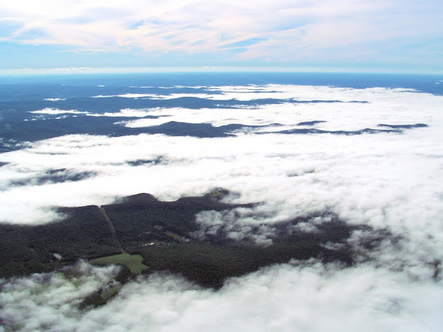
Nearing the southern tier of New York, it became evident that a flood had taken place.  A torrent of water vapor had spilled throughout the valleys such that only the tops of the surrounding hills remained above it.

 
Lonely hilltops project above the encroaching tide of partially-condensed water.


The nebulous sea persisted throughout much of the southern tier and into northern Pennsylvania.


The Cattaraugus County - Olean Airport perched on a high bluff overlooking a misty morning sea.

For a time, we were the only arrivals at The Silver Wing.  We sat on the deck overlooking the ramp, watching airplanes come and go, and devouring excellent frittatas while Cheesburger in Paradise and other Jimmy Buffet classics played in the background.

By the time we returned to New York, the vapors had retreated, leaving fog-ravaged valley towns in their wake.  We slipped to runway 10 at Le Roy in a light, but direct, crosswind.  With the planting of an upwind wheel, followed by settling the rest of the aircraft to Earth, we concluded our morning breakfast run.

Nine years ago today, four aircraft were forcibly pressed into the service of an unspeakable nightmare.  This morning, we soared peacefully above a fog obscured landscape and drank in the beauty of the Earth below.  Flying for the sake of flying.  As it was meant to be.