
| Date | Aircraft | Route of Flight | Time (hrs) | Total (hrs) |
| 13 Jun 2011 | N21481 | FMY (Fort Myers, Florida) - MTH (Marathon, Florida) - FMY | 3.3 | 944.2 |
Kristy and I took a morning trip to the Florida Keys. The Bear remained in Fort Myers with Granny and Granddaddy and had her own Numeroffian adventure. So for this trip, Kristy rode in the front seat and even set a frequency or two on the radio just like old times.
The only public use airports in the Keys are Marathon and Key West. Of the two, Marathon appeared to be simpler to manage and less expensive. Frankly, I just wanted to sight see over the islands and had no need to go all the way to Key West. We decided that Marathon would be "best in the long run".

This is I-75, also known as Alligator Alley, because it runs directly across the Everglades. I could not imagine a more desolate stretch of highway anywhere else this side of the Mississippi.

The Florida Everglades with the Gulf of Mexico just beyond. The water was so still that it reflected the clouds like a mirror.

Miami Center maintained a watchful eye on us as we flew over this beautiful, but desolate landscape.

My original plan was to fly to Key Largo, closest to mainland Florida, then follow the chain of islands to Marathon. Once we reached the southern tip of Florida, however, it was clear that there were so many little islands within gliding range that we diverted across more "open" water. Another good reason to do this was that President Obama was expected in Miami, shutting down the airspace in a 30 mile radius. The Temporary Flight Restriction was not scheduled to become active until 4:00 that afternoon, but I gave it a wide berth anyway in case the activation time changed while we were en route.

Starting out across the Atlantic. The chain of islands carrying US-1 to Key West can be seen at the top of frame.

We quickly reached the Keys and flew north of them within gliding distance. The water was so amazingly clear that every contour of the bottom was visible.

This Key is a little off the beaten path of US-1.

This Key had a sandy peninsula projecting northward.

At the end of that peninsula, a mammoth residence was being constructed. I suppose that having your own peninsula is the next best thing to having your own island.
 |
| Photo by Kristy |
Miami Center cut us loose within a few miles of Marathon and we began a descent.
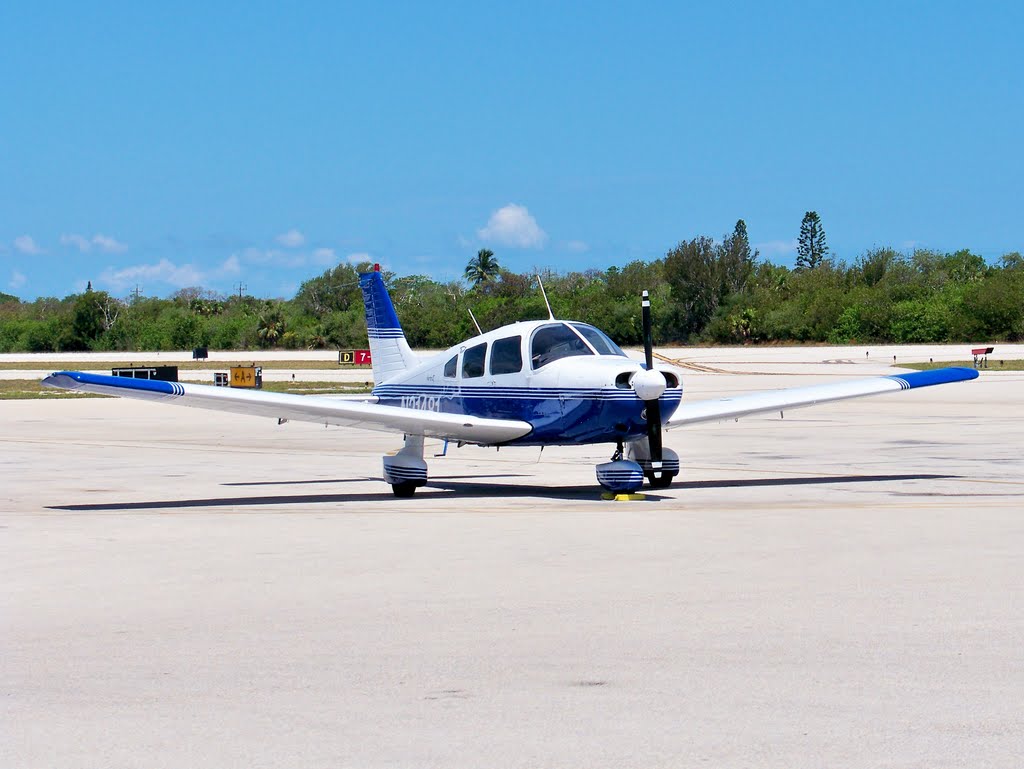
Here is Warrior 481 parked on the ramp at the Marathon Airport, our new southernmost point of landing.

We had a late second breakfast (who knew that hobbits flew airplanes?) at the Island Tiki Bar and Restaurant, complete with thatched roof for authenticity. After all, any place known for its deep fried key lime pie has to be good, right? We missed the start of lunch by five minutes, but our breakfasts were fantastic.

This was the view from our table as we ate. When we were done, Chris (or Kris?) from the Marathon Airport picked us up for the return trip. In casual conversation, we discovered that Chris (Kris?) was from a suburb of Rochester immediately south of where we live. Crazy.

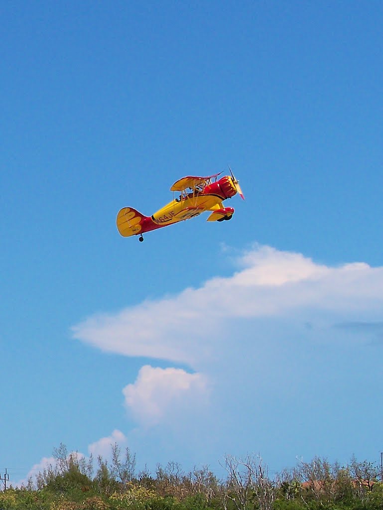
Conch-Air maintains a beautiful WACO biplane named "Sweetie Pie 2" for sightseeing flights. Here it is taxiing past Warrior 481 for departure.
After watching Sweetie Pie 2 depart, we also took to the sky hoping to return "home" before any thunderstorm activity could start in Fort Myers (it never did, the place stayed dry as a bone).

Departing from Marathon, we were aligned with US-1 traveling northeast back toward mainland Florida.

Looking to the west, we could see cumulus building over the Gulf.

One buildup in particular hovered just offshore from the western tip of Florida. The clouds building from frame center toward the right were moving inland. Our objective was to miss those without flying under the gathering storm offshore, which we accomplished without any difficulty.

This was taken looking north toward the southern tip of Florida. We were still "island hopping" at this point, flying within gliding range of the several islands spanning the gap between the line of Keys along US-1 and the mainland.

Looking due west over the Gulf from mainland Florida, we saw this massive thunderhead taking shape miles away. To paraphrase Gary Larson, this is one of nature's ways of saying "do not touch".

We overflew the Ten Thousand Islands as we flew along Florida's gulf coast. Ten Thousand Islands? Is this all about Florida trying to one-up New York?

This is Marco Island. The population density looks to be a little high for my liking.

Here's a close-up of Marco (high zoom from 8500' and miles away). Yikes! Marco Island is all canal and housing.

With Naples in sight, Fort Myers approach issued an interesting set of vectors.
"Warrior 481, fly direct Lee County VOR, descend your discretion to three thousand five hundred, and cross International Airport at midfield."
Ummm... This is where some local knowledge would have helped. I had no idea where Lee County VOR was and it was not immediately obvious to me that "International Airport" was Southwest Florida International (Fort Myers, RSW). I scanned the sectional for a moment before finding the Lee County VOR on the field at RSW. In the pause I took to get my bearings, air traffic control issued the vector again and I repeated the instructions.
Once I had my bearings, the vector made a tremendous amount of sense. Page Field, northwest of International was landing on runway 23. By bringing me directly over the top of International at midfield, I crossed their runway on an orthogonal trajectory that would establish me on an extended left base for the active runway at Page. Clever.
And so, for the first time outside of a training situation, I actually needed to tune and track a VOR. And I did. And it was good.

We rode the beam over a dense sprawl of civilization, crossed International's runway at midfield, and were passed to Page Tower. The landing at Page was uneventful, though somewhat tense given that we preceded a jet whose pilot was completely unable to get a visual on us despite multiple prompts from Page Tower.
 |
| GPS ground track (green = FMY - MTH, red = MTH - FMY) |
Our excursion to the Keys was some of the most enjoyable flying I had done in a long time. Calm air, gorgeous scenery, the thrill of going someplace new, and time with my wonderful wife. It does not get any better than that.
Just downright beautiful. It's crazy how desolate everything is there aside from the roads. Love, love, love the photos from this part of the trip!
ReplyDeleteI googled Ten Thousand Islands and came across your photos. Oh, the one with the giant house! Disgusting! As a native Floridian, it hurts me to see.
ReplyDelete"Hi. I’m an asshole who wants to live in the Keys, but I don’t really like that the Keys are just a bunch of mangrove islands, so I’m going to import sand from the Bahamas until it looks more like what I think it should look like, and on that sand I’m going to build the most digusting monstrosity of a residence ever so everyone can immediately see how much of an asshole I am."
That's basically it. I hope a hurricane devours that place.
Also, sorry for shitting on your post like that. I just couldn't help myself after seeing that house.. I should have mentioned how much I enjoyed your other photos. Lovely.
ReplyDeleteI swear, Katie, I take zero responsibility for the monstrosity I photographed. It was a moment of, "holy crap, look at that freakin' thing!"
ReplyDelete