"Are You on the Right Road?"
Standing boldly at the confluence of I-75 and Dixie Highway in my Michigan hometown, a massive portrait of Jesus confronts commuters with the caption, "Are you on the right road?" The sign is so well-known that it made an appearance in the 1989 documentary Roger & Me, despite that film being set in Flint, MI one county and thirty Interstate minutes north of my childhood home. As a teenager, I was amused by the double meanings it intimated, a superposition of the spiritual as well as the literal considering that it sat at an actual highway crossroads. Sometimes seeing that sign would inspire me to reassess my chosen route home while completely ignoring the ecclesiastical overtones.
Piloting is all about decision making. While it is true that all aviators need to understand the mechanics of flight, the rules of flight (both natural and legislated), and the weather and other factors impacting flight, these are actually the easy parts. It is the decision making that most challenges people. Where to go? When to go? Whether (and weather) to go? How to go? And those decisions are just the ones required to get airborne. Once cruising along on manmade wings, good pilots are constantly reassessing their circumstances, effectively asking themselves, "Am I on the right road?" Prudent consideration and prompt action necessarily bookend the answers to this essential question of flight.
Maybe I'm a slow learner, but it seems to me that improved decision making is a skill that a pilot might spend a lifetime refining. How else can I explain the fact that I am on the verge of attaining 3,000 flight hours, but still occasionally make really poor decisions?
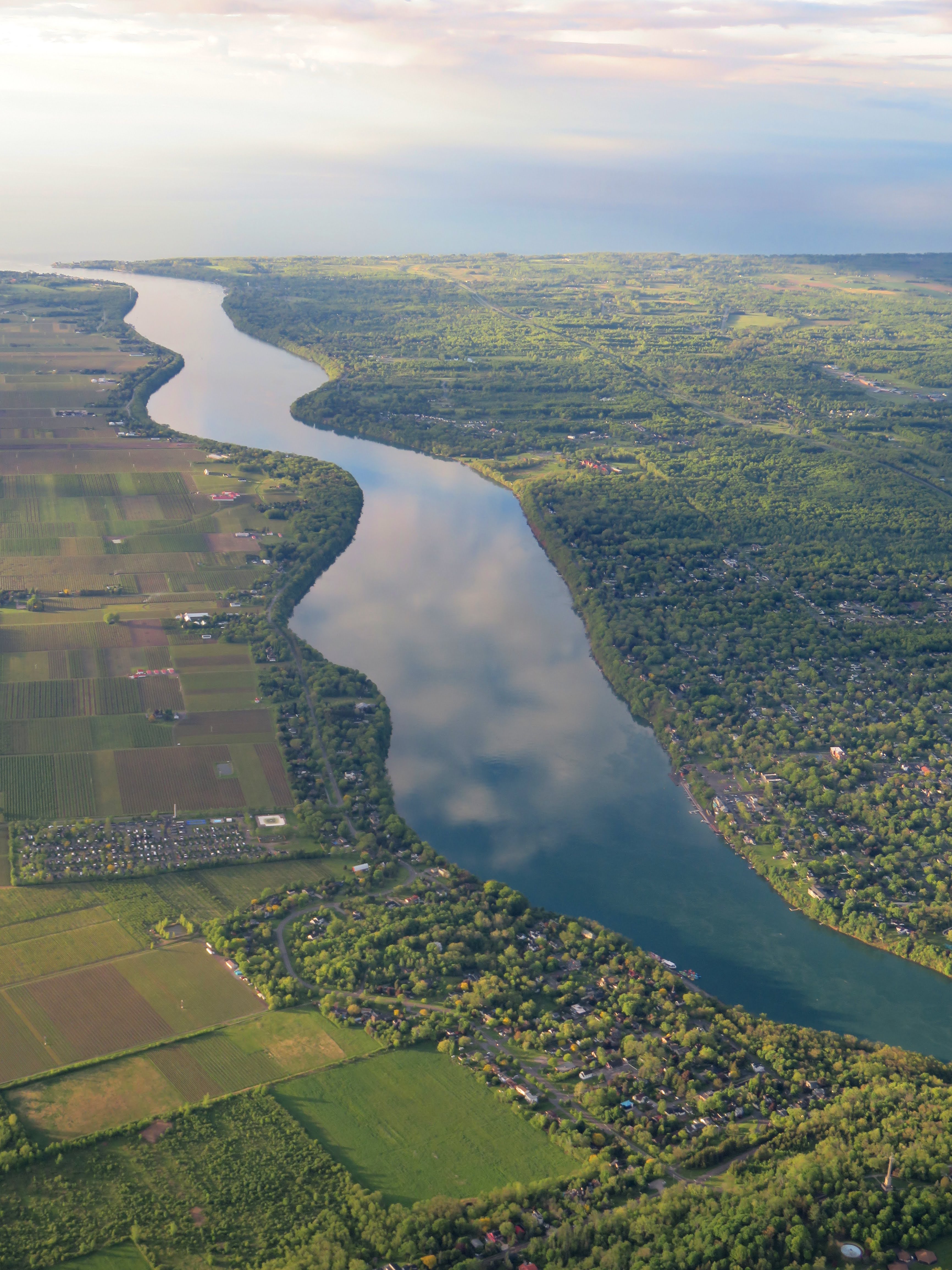
A Finger Lake Points the Way
| Date | Aircraft | Route of Flight | Time (hrs) | Total (hrs) |
| 26 May 2025 | N21481 | SDC (Sodus, NY) - 17NK (Reading Center, NY) - SDC | 1.3 | 2988.8 |
 |
| Seneca Lake |
It was a beautiful morning. We zipped through a blue sky along the cobalt glacial scar that is Seneca Lake, Warrior 481 parting a benign atmosphere that hardly stirred. The lake off our left wing pointed the way to Re-Dun Field (NK17), a private airport that disappeared from GPS databases a couple years ago when Garmin adjusted their inclusion criteria for private airfields. Pilotage was the rule of the day for finding Re-Dun. Every Memorial and Labor Day holiday, Re-Dun hosts a pancake breakfast and opens their somewhat unique facility to all.
 |
| Re-Dun Field as depicted on the Detroit sectional chart. |
Despite being charted as an airport with an unimproved surface (the open circle in the above chart), runway 17-35 at Re-Dun is actually paved. However, the runway is not much wider than the 10 foot wheelbase of a Cherokee. This "sidewalk" is flanked by grass for 30 feet on either side of the centerline. Obviously, such a narrow runway is a novel feature of the airport. Another is the Awe-Ja-Magic automatic pancake making machine, a Rube Goldberg invention of the late Clarence Sebring that fascinates all who come seeking breakfast at Re-Dun.

Accompanying me were Alyssa, who was on the verge of taking her private pilot check ride, and The Bear, who has wanted to see the Awe-Ja-Magic in action for years. It was the first flight to Re-Dun for both. The airplanes of multiple club members were in trail behind us.
Road Hazard
 |
| Looking south over Re-Dun. |
We were first to arrive over the airport. Absent any chatter on 122.9 MHz, we overflew the field to decide on landing direction. With such calm wind, either direction was feasible and, for me, the choice came down to practicality. Airplane parking and all airport buildings are on the south end of the runway and landing to the south simplifies ground operations and avoids tying up the runway for other arrivals while back-taxiing southward after landing to the north.
As we orbited the field about 500 feet above pattern altitude, we noticed a small aircraft flying low over the middle of the field. (This is captured in the photo above.) "What's he doing?" Alyssa asked.
It was a good question. The other aircraft -- later revealed to be a single seat ultralight -- skimmed low over the middle of the airport, flying slowly westbound without broadcasting any intentions on frequency. We declared for runway 17 and departed the area to the southeast for a descent to pattern altitude and a 45° entry to the downwind.
On a left base leg in the pattern, I spotted the silent ultralight landing to the north (runway 35) on the narrow runway. If it had been on a midfield left crosswind when we spotted it earlier, I was stunned that it could still be airborne and decided that it must be incredibly slow.
As I processed this, I heard Alyssa say, "Go-around." Good instinct. But as we continued watching, the ultralight landed, stopped on the runway, and turned off onto the adjacent grass. "Oh," Alyssa commented, echoing my own internal thoughts. "He's cleared the runway." Now that the ultralight was off the runway, I decided to proceed with the landing rather than go-around.
On very short final, I realized a problem with this strategy. The ultralight taxied along the side of the runway toward parking with such glacial slowness that its speed was probably best measured in geological terms. Worse, it was taxiing too close to the pavement. Although it had "cleared" the runway, it was not far enough off the pavement and still presented a collision hazard considering the Warrior's 35 foot wingspan.
I debated going around for the second time that morning, but worried that accelerating toward the slow moving ultralight might actually be a recipe for disaster if I could not establish a positive rate of climb in time. I cross-controlled the Warrior into a slip to steepen the descent and immediately got on the brakes when we touched down. On the ground, we rapidly caught up to the ultralight.
I brought the Warrior to a near stop off the ultralight's aft starboard quarter, but now we were trapped on the runway by the single seat ship as it crawled toward parking. This was not a comfortable situation as all pilots are trained to vacate runways as soon as possible so as not to pose a hazard to others attempting to land. As far as I could tell, the ultralight pilot was completely unaware of our existence.
Finally, the ultralight turned left and ambled toward available parking. From past experience, I knew that the turf in the parking area (actually a short grass crosswind runway) tended to be thick and the underlying soil soft. Power and momentum are a pilot's friends whenever negotiating this area. I did not want to follow the ultralight too closely because it was taxiing slower than I would need to go, but I also did not want to tie up the runway any longer than necessary. I waited until the ultralight was halfway between the runway and the nearest available parking spots before I throttled up and followed it in.
The turf was softer than usual and the Warrior struggled somewhat. Another pilot watching all of this ran forward and gestured for us to taxi more on the right side of the path where the ground was firmer. As I made this correction, I broadcast to the other airplanes coming in behind me. "The turf is softer than usual, taxi toward the right side."
Stuck
We were managing well enough, but slowly catching up to the ultralight. Just before reaching the parking area, the ultralight stopped altogether -- presumably for the pilot to contemplate his options -- and we caught up to it quickly. As I halted the Warrior behind the ultralight, I felt our wheels sink into the soft turf and uttered a string of expletives under my breath. DAMMIT! Eventually, the ultralight throttled back up, chose a parking spot, and maneuvered into it. He shut down, removed his helmet, and toddled off to breakfast.
Even at full take-off power with full aft elevator, the Warrior would not budge. We were completely stuck. I shut down and encouraged Alyssa and The Bear to get out quickly. In the meantime, Ed had landed in his Archer II and powered around us to the right through the soft turf to parking. Lee in his Piper Colt did similarly. The next arrival was Jamie in his Searey. Rather than go around me to the right, he went left and promptly got himself stuck as well.
Ed, his passengers Joe and Randal, and the pilot who originally directed me toward the right side of the grass taxiway ran forward to help move the Warrior. There was no pulling her forward and I suggested that she would be easier to push than pull. That proved to be the case.
It was no wonder we could not pull the Warrior forward, the nosewheel was completely dug in.


Batter is initially metered onto the inner diameter of the griddle. The brilliance of Sebring's Awe-Ja-Magic pancake maker is the rotating griddle and its translation of distance travelled to cooking time.
Once pancakes are fully cooked on one side, the Awe-Ja-Magic flips them from the inner diameter to the outer for one more orbit on the circular griddle. When I passed through the kitchen area, I found Alyssa and The Bear already happily taking video of the pancake contraption. Breakfast was delicious and the company was excellent. Over breakfast, someone noted that when Ray arrived in his helicopter, he tried three different parking spots before finding one that he deemed firm enough for landing.
 |
| Photo by Alyssa. |
Ed, his passengers Joe and Randal, and the pilot who originally directed me toward the right side of the grass taxiway ran forward to help move the Warrior. There was no pulling her forward and I suggested that she would be easier to push than pull. That proved to be the case.
 |
| Photo by Alyssa. |
It was no wonder we could not pull the Warrior forward, the nosewheel was completely dug in.

Thanks to everyone's help, we pushed Warrior 481 out of the way and into a suitable parking spot. I had a flashback to my first fly-in pancake breakfast in 2004 at Torchport when I also got stuck in soft grass and a small army of other pilots came to my aid.

Next, we ran to Jamie's stricken amphibian. The turf was so waterlogged that it actively squelched with each step.
 |
| Photo by Alyssa. |
As a taildragger, the Searey responded well to pulling and in moments we had Jamie's airplane settled in the parking area. Perhaps not in a way that satisfied my parking OCD, but well enough. Fortunately, no one else got stuck that morning. Once we had everyone gathered together, we proceeded to the breakfast hangar.
| A Towering Wonder of the Pancake World The Awe-Ja-Magic was actively making pancakes that morning and, as usual, the machine had a small army of volunteers watching carefully to ensure proper function. Much like a poorly supervised toddler, things go off the rails messily when the machine gets itself into trouble.  |
| Photo from May 27, 2019. |
 |
| Photo from May 27, 2019. |
Batter is initially metered onto the inner diameter of the griddle. The brilliance of Sebring's Awe-Ja-Magic pancake maker is the rotating griddle and its translation of distance travelled to cooking time.
 |
| Photo from May 27, 2019. |
Once pancakes are fully cooked on one side, the Awe-Ja-Magic flips them from the inner diameter to the outer for one more orbit on the circular griddle. When I passed through the kitchen area, I found Alyssa and The Bear already happily taking video of the pancake contraption. Breakfast was delicious and the company was excellent. Over breakfast, someone noted that when Ray arrived in his helicopter, he tried three different parking spots before finding one that he deemed firm enough for landing.
Fuzzy Memories
 |
| Focus, Chris. Focus! |
Because it was such a big group, we made a point of getting a group photo. For some reason, my memories of the event and those who attended have become a little fuzzy.

As in past years, a number of visitors to the airfield included local Mennonite families that crowded around the airplanes. I was reminded of seeing people crowd around Warrior 481 on past visits to the Alton Bay Ice Runway.

Ed's well-dressed Archer II also received plenty of attention. At one point, I watched a young girl pat the wing as though the airplane was a puppy.
Exodus

When it was time to go we monitored the Searey, standing ready to help in case Jamie got stuck again. Fortunately, he had no issues taxiing out and, this time, he kept to the higher, drier side of the taxiway.

From Two Six Romeo, Alicia bade her adoring public a fond adieu.

From the controls of his airplane, Tom contemplated his path away from the soggy parking area.

I was particularly interested in Tom's success in taxiing out as his airplane was probably slightly heavier than mine.

I had a nice opportunity to admire Lee's "Coltish" airplane. During breakfast, Lee apologized for zipping around us while we were stuck in the turf. I thanked him, but no apology was necessary because he had done the right thing. If he had stopped, he would have likely been stuck too.
When it was our turn, some of the others helped me manually turn Warrior 481 around to point directly toward the runway. With The Bear and Alyssa ready to go and the engine idling, I checked my surroundings while simultaneously reaching forward to advance the throttle.
What I saw stayed my hand. "Ugh, this guy again." From our right, the ultralight crept past on its way to the runway and I resolved to wait until it was no longer a factor before moving. It eventually reached the runway, spent several more minutes fully back taxiing so as not to waste a single foot of asphalt, and promptly went airborne after what appeared to be a ten foot ground roll.
Power was necessary in the taxi, but we escaped the grass without significant difficulty and launched to the north for the same reason that we landed to the south on arrival: practical expediency. Overall, our mass departure was less fraught with problems than the arrival and no one else got stuck.
 |
| Seneca Lake, this time pointing the way home. |
 |
| Looking toward Penn Yan and the east fork of Keuka Lake. |
More clouds moved in since we were aloft earlier in the morning, but the day remained a beautiful one to fly. Once back in the hangar, it was clear that the bottom inch of Warrior 481's wheel pants were painted with mud from where the grass rubbed against them. Getting stuck at Re-Dun was right on the edge of being catastrophic, at least for the wheel pants.
Debrief
When the flight was done, I found myself still annoyed with the ultralight driver for being cartoonishly slow, for choosing not to use a radio (legal, sure, but...), and for obliviously puttering around as though operating the only aircraft in the universe. However, while I think there is some minor validity to my irritation, the ultralight pilot did not actually do anything wrong. The biggest problem of the morning came down to one bad decision of mine: I should have gone around when we first saw the ultralight landing in the opposite direction. This was a branch point that spawned multiple undesirable outcomes that fell into place like dominoes. Had I gone around:
- I would have avoided the potential conflict on landing. Sure, the ultralight "cleared" the runway before we turned to final approach and that would have been enough at any other airport, but not with Re-Dun's sidewalk of a runway. The ultralight may have been off the pavement, but it was not actually clear of the runway.
- I would have not been trapped tying up the runway waiting for the ultralight to mosey out of the way. If I had gone around, the ultralight would have probably made it to parking in the time it took me to negotiate the pattern again and land.
- I would not have needed to stop behind the dithering ultralight partway to parking and sunk in to the soft turf. While the Warrior was OK, I feel terrible about the damage to the turf. It also could have been worse. The surface could have been softer, we could have sank even deeper, and I could have damaged my airplane.
This is why it is important for pilots to constantly and critically assess their circumstances throughout every flight, just like the sign in my hometown prompts southbound drivers to reconsider, "Are you on the right road?" When I chose to continue the landing at Re-Dun Field rather than going around, I chose the wrong road. While it all worked out in the end, there is something to the old axiom: "A superior pilot uses his superior judgment to avoid situations which require the use of his superior skill."