Still No Moomers!
We returned to AvFlight where, despite a Moomers re-supply since our arrival the evening prior, they had already run out again! We readied our airplanes for flight and launched from runway 36. Our plan was to fly due west to the Sleeping Bear Dunes, turn north along the lakeshore to survey the dunes, then hop over to the Manitou Islands for additional aerial sightseeing. Because aircraft are required to fly no lower than 2,000 feet over the park and the highest elevation in the dunes is about 1,000 feet, we flew the whole route at 3,000 feet. After visiting the Manitou Islands, we planned to check out Woolsey Memorial Airport (5D5), a well-regarded turf only airport in Northport, MI near the tip of the Leelanau Peninsula, Michigan's pinky finger. Woolsey Memorial was a carry-over from my list of places to explore in 2023 that I did not manage to visit.
Sleeping Bear from the Air
| Date | Aircraft | Route of Flight | Time (hrs) | Total (hrs) |
| 04 Aug 2024 | N21481 | TVC (Traverse City, MI) - 5D5 (Northport, MI) - TVC | 1.7 | 2878.5 |
We launched from Cherry Capital Airport over the West Arm of Grand Traverse Bay before turning westbound toward Michigan's western coastline. Along the way, we passed Silver Lake and some of the other bodies of water where I worked toward my seaplane rating in 2023.
As we approached Lake Michigan, Platte Lake and Crystal Lake were visible as the two largest inland bodies of water off our left wing. Point Betsie is the prominent point projecting into Lake Michigan.
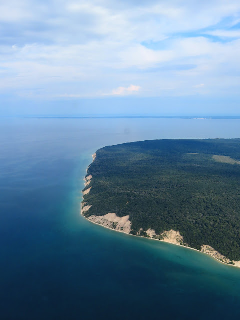
Turning northward, we could take in the full extent of our travels that morning. We turned to parallel the lakeshore just south of the Empire Bluffs. The main portion of the Sleeping Bear Dunes were visible farther north with Glen Lake to the east. And finally, on the horizon, were the Manitou Islands. Fortunately, the haze from wildfire smoke was significantly diminished from the day before.
As we flew along the lakeshore, we could see where the Empire Bluffs Trail precariously followed along the top of the dune.
Finally, we were abeam the main portion of the dunes with the Lake Michigan Overlook to the right at the highest point of the dune. The Dune Climb is farther north and immediately between Glen Lake and Lake Michigan.
Flying the shoreline was not only scenic, but it gave tremendous perspective on the scope of the dunes that we explored from the ground that morning.
A groove in the sand worn by climbing tourists was even evident from the air. I wondered at the boat parked near the bottom of the groove. Was it there to catch the people that went tumbling down the dune toward the water?
The Bear Cubs
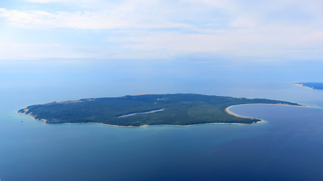
We came first to South Manitou Island with its distinctive natural harbor. Altitude restrictions for the park also extend to the Manitou Islands, so we maintained 3,000 feet. South Manitou is famous for its dune formations and old growth cedar groves, some dating back as far as 500 years.
The portion of Lake Michigan between the islands and the mainland is known as the Manitou Passage and is considered one of the most dangerous routes in the Great Lakes. The first lighthouse to occupy this spot was built in 1838. The current 104 foot tall lighthouse tower was built in 1871.
South Manitou Island's harbor was the only natural harbor deep enough to shelter ships when severe weather was encountered between Chicago and the Straits of Mackinac.
South Manitou is unpopulated, but legacy buildings from prior habitation remain as a visitor center and museum.
 |
| Tip of South Manitou Island's harbor. |
I love the colors created by varying depths of water in Lake Michigan and I have ever since I first saw them from the cockpit of Warrior 481 20 years ago.
We flew a complete counter clockwise circle around the densely wooded South Manitou Island.
The northwest face of the island is comprised of perched dunes very similar to the Sleeping Bear Dunes on the mainland.
Below, we could see the remains of the Francisco Morazan, a steamship that ran aground in a storm on November 28, 1960. The ship had been in service for 38 years before its accident, sailing under six different flags and bearing eight different names. Now it rots off the southern tip of South Manitou Island, still packed with a payload that delightfully includes baled human hair.
When it ran aground, it was racing to reach the Atlantic Ocean before the St Lawrence Seaway closed on December 3. It obviously fell well short of that goal.
This is my favorite photo of the day taken from south of South Manitou Island and looking toward North Manitou.
 |
| South Manitou Island Lighthouse. |
From South Manitou Island, we transitioned to North Manitou.
North Manitou Island is also completely unpopulated except for park rangers. Former settlements on the island were built to supply cord wood to Great Lakes steamers. As technology evolved, the need for wood diminished and forests have retaken the island, giving rise to nearly 15,000 acres of pristine wilderness.
Aerial survey of the islands led to one incontrovertible fact: neither one of them is particularly bear shaped.
Woolsey Memorial
After circling North Manitou Island, Alyssa took the controls and flew us back to the mainland. She followed the shoreline along the west side of the Leelanau Peninsula toward Woolsey Memorial Airport in Northport, MI.
 |
| On downwind for runway 27 at Woolsey Memorial. |
Woolsey Memorial features two turf runways, 9-27 and 16-34. 9-27 is the longer of the two and reputedly the smoothest. Faced with a relatively ambivalent wind, we chose runway 27.
 |
| Warrior 481 landing at Woolsey. Photo by Alicia. |
It was Alyssa's first experience on a grass runway and I was pleased to give her a smooth landing. Woolsey is a beautiful facility. One thing that I miss about all public use grass runways in Michigan is that they are clearly outlined by yellow cones. This is not something that occurs consistently in the East. Without such markings, it is still possible to discern landing strips, but I appreciate the convenience of explicit markings as done in Michigan.
 |
| Our ForeFlight ground track from Traverse City to Woolsey via the Manitou Islands. |
 |
| Looking down runway 27. |
Woolsey Memorial Airport is a registered Michigan Historic Site. A marker near the terminal building reads:
"CLINTON F. WOOLSEY
MEMORIAL AIRPORT
In 1926, Captain Clinton F. Woolsey became an engineer for the U.S. Army Air Service. He was one of ten pilots selected to serve in the Pan-American Good Will Flight to Central and South America that occurred from December 1926 to May 1927. Clinton died when his plane crashed in February 1927. His funeral and burial took place in Northport. His father, Byron Woolsey, donated eighty acres of his dairy farm for this memorial airport, including a fieldstone structure believed to have been his creamery. Leelanau Township gave 120 more acres. The Civil Works Administration assigned workers to the airport project in winter 1933-34. The farmland became the runway, and the creamery became the terminal. The Clinton F. Woolsey Memorial Airport was dedicated on July 14, 1935."
 |
| Looking down runway 34. |
Woolsey is outfitted with one of the most unusual terminal buildings that I have ever laid eyes on. The former dairy farm creamery building is striking. It was locked, which limited our exploration, and also subject to a funding drive to finance its restoration.
 |
| Photo by Alicia. |
A list entitled "free calls" was displayed on the airport payphone. Alyssa gave it a try but was unable to connect with anything particularly useful.
"BEEP-BEEP-BEEP The number you have dialed was disconnected in the previous century. Please hang up and try again using a device from the current millennium."
"You don't frighten us, English pig-dog! Go and boil your bottoms, son of a silly person. I blow my nose on you, so-called Arthur-king, you and your silly English kaniggets"
Huh. When did Tom learn to speak French?
Having satisfied our desire to explore new places and sample a pristine grass runway, we returned to our airplanes that were once again faced with landing on the unforgiving pavement of Traverse City's Cherry Capital Airport.
 |
| Tom and Alicia preparing to depart Woolsey. Photo by Alyssa. |
The real question of the day was: how did Petrie like landing on grass? The Cherokee 180 gave no answer. Of course, if Warrior 481 could talk, she would want to return to the grass runway at South Haven.
We flew due south along the West Arm of Grand Traverse Bay.
 |
| Photo by Alicia. |
Alicia captured this beautiful shot of the Manitou Islands as we flew back to Traverse City.
 |
| Cherry Capital Airport seen on a wide left base for runway 10. |
I took the opportunity to indulge in a nostalgic Oberon while Tom ordered something from Founders. "Where is Grand Rapids, anyway?" Tom asked about the brewery.
When I pinpointed its location on my hand, Tom gave me a "WTF?" look that caused the waitress to burst into laughter. "Well, at least one of you is from Michigan!" she said in reference to my use of the notorious "hand map".
We returned to the Day's Inn and Suites, driving past Tom's Food Market (even Tom did not know that he owned a market) and the terrifyingly rabid looking bear statue outside of Traverse City Bear Company. It was another excellent full day of exploration and I think all members of our party slept well that night.
My original plan for our final day in Michigan was to depart Traverse City in the morning and fly home via Kalamazoo for a tour of the Air Zoo, but weather forecasts were not promising and that plan of action was in serious doubt.


No comments:
Post a Comment