More "Billy Joel Geography"
| Date | Aircraft | Route of Flight | Time (hrs) | Total (hrs) |
| 13 Aug 2022 | N21481 | SDC (Sodus, NY) - MTP (Montauk, NY) - RME (Rome, NY) - SDC | 5.8 | 2516.6 |
 |
| Over Connecticut, about to go feet wet. |
From 9,500 feet, I reduced power slightly and started a long slide downhill over Long Island Sound toward Montauk, NY.
 |
| Connecticut coast. |
 |
| More Connecticut. |
 |
| Even more Connecticut. |
 |
| Orient Point and Plum Island. |
In the descent, I compared the sectional chart to what I saw beyond the Plexiglas in an effort to put names to the landmarks. I passed over Gardiners Bay just west of Gardiners Island with my destination on the easternmost tip of Long Island in sight. Block Island was visible twelve miles beyond Montauk.
 |
| Looking east along Long Island from over Gardiners Bay. |
After its settling by Lion Gardner in 1639, Gardiners Island has remained a privately-held island ever since. The island obviously featured an uncharted pair of unpaved runways and was evidently once home to Captain Kidd's buried treasure. In fact, maybe those aren't runways at all, but something left behind to mark the spot.
An unexpected gift of aviating in the northeast is that the experience has brought to life places that I had only heard of growing up in the Midwest. The region features what I like to call "Billy Joel Geography" because I first heard of several of these places in the song Downeaster Alexa.
"We took on diesel back in Montauk yesterday,
And left this morning from the bell in Gardiners Bay."
 |
| East end of Long Island with Block Island faintly visible in the distance. |
Still descending, I crossed the north shore of Long Island over Napeague. Far below, two moving objects over the beach caught my eye.
It was what appeared to be a Piper Pawnee towing a banner. Seeing how the banner was obviously tipped toward ground observers, I wondered how that orientation was achieved.
 |
| Montauk. |
Still descending, the extensive beach along the ocean side of Long Island reminded me of the Outer Banks. I should not have been surprised. Montauk is part of the Hamptons, the playground of the northeast's upper crust. Until arriving there, I had not processed how far to the east Long Island extended. Montauk was actually slightly east of Groton, CT.
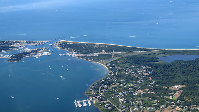
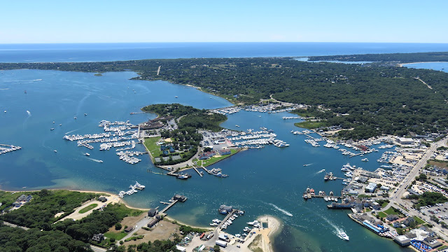
A channel from Long Island sound connected Lake Montauk to the ocean. The spot was home to several marinas.
Down the Rabbit Hole
From the chart, I knew that the Montauk Point Lighthouse was situated on the eastern tip of Long Island and I maneuvered to get a closer look.
 |
| Eastern tip of Long Island with the Montauk Point Lighthouse and the Camp Hero radar visible. |
It was not until reviewing the photographs at home that I noted the massive radar dish projecting above the forest canopy. This observation drew me down quite a rabbit hole. It was a cold war relic, the last surviving AN/FPS-35 long range radar installation once part of a nationwide early warning system.
The Montauk radar was installed at Camp Hero, originally a World War II era US Army base built to operate a coastal defense battery. Base structures were disguised to make the outpost resemble a fishing village, though that illusion was destroyed circa 1955 with the construction of the radar tower. As an Air Force station in the 1980s, conspiracy theories of bizarre and unethical experiments swirled around Camp Hero. As described in a series of books called Montauk Project, local townspeople were allegedly abducted and subjected to secret Air Force experiments into mind control, teleportation, and time travel. Inspired by these rumors, a pair of brothers wrote a treatment for a television series to be called Montauk. However, after being picked-up by Netflix, the authors were convinced to fictionalize the setting. Thus, Hawkins, IN was born and the series renamed to Stranger Things.
A Washington Administration Holdover
In 1789, the first public works act of Congress transferred responsibility for existing and future lighthouses to the federal government. First lit in 1797, New York's first lighthouse was authorized by the Second United States Congress under Washington. It remains the fourth oldest operational lighthouse in the United States.
Standing 110 feet tall, the lighthouse was easy to spot from a few miles away.
Restoration of the lighthouse is ongoing, currently with a focus on repairing the brick and mortar structure of the tower. This required stripping many layers of paint from the landmark, hence its faded appearance in these photos.
 |
| Looking westward along Long Island from Montauk Point with the airport and Lake Montauk visible. |
Airport #247
I flew a descending arc out over Long Island Sound to enter the pattern on a 45° for runway 6 at Montauk. A twin Piper Seneca was also inbound from the west.
 |
| The many marinas of Lake Montauk. |
 |
| Left base for runway 6 at Montauk. The Camp Hero radar can be seen projecting over the trees. |
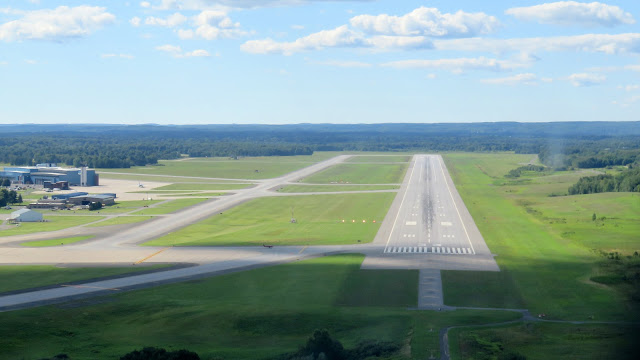
I made a landing that was most definitely not one of my best at Montauk. Like a divided highway, the parallel taxiway that took me back to the ramp was separated from the runway by a tree line. I crossed what appeared to be a very short and defunct crosswind grass runway.
For an airport providing absolutely no services, I was surprised to be marshalled to parking. Then again, parking was limited and the ramp fairly crowded and I appreciated not needing to guess at an appropriate spot. The attendant parked me with nearly my entire right wing extending over the non-movement area line, a place that I would not have chosen if left to my own devices. The Seneca pilot landed and was directed to park off my left wingtip.
 |
| Ramp at Montauk. |
Montauk raised their parking fee to $40 on August 1. Ownership claims that this was done to discourage casual visitors from trying up limited ramp space. Frankly, it seemed like they could rehabilitate the former grass runway into transient parking to ameliorate that issue. I would not mind a brief hike back to the ramp if it saved me a landing fee. Fees are not charged on site, but rather collected by an outfit called Vector that records tail numbers of landing aircraft from strategically placed cameras and bills the registered owners months after the fact.
I departed the property along with the pilot and passenger of the Seneca that landed after me. I opened the conversation with a compliment on the Seneca's paint job, which the pilot explained was new. As we walked toward our mutual lunch destination, we discussed aircraft upgrades. He had recently installed a full Garmin glass panel, but was still operating a legacy autopilot as he waited for Garmin to add his aircraft to the list of approved airframes. In contrast, I had a 50/50 glass/legacy panel and the new Garmin autopilot, so I was able to provide some commentary on its operation.
About halfway to Inlet Seafood, a car travelling in the opposite direction with New Jersey plates abruptly stopped. The single occupant gesticulated at us and asked if we were headed to Inlet Seafood. When we acknowledged that we were, he offered us a ride. The three of us looked at each other, formed a wordless consensus, and accepted.
He made an awkward U-turn, cutting off traffic travelling in the opposite direction such that I wondered about the wisdom of climbing into a car with him. But he saved us a bit of a walk and clearly had nothing but good intentions.
Buttery, Crustaceany, Deliciousness
Inlet Seafood is owned by a group of local fisherman with a mission of cutting out the middleman and getting fish directly from their boats to our plates.
The restaurant is quite large, open, and airy with multiple balconies for outdoor dining. Large windows surround the indoor dining spaces, giving excellent views of activity in the channel between Lake Montauk and Long Island Sound.
 |
| Street side entrance of Inlet Seafood. |
Inlet Seafood was an interesting dichotomy. It was upscale while still homey and beach appropriate. Staff were extremely friendly and prompt.
As a well-known sucker for lobster rolls, that's what I ordered. It was not so overloaded with lobster as what we got from Red's in Maine, but it was quite possibly the best tasting lobster roll I have ever had. Even the roll itself was cooked grilled-cheese style for an extra infusion of buttery goodness. Let's be honest, between the lobster roll and the landing fee, this was an expensive excursion. But it was so satisfyingly delicious and the locale so beautiful to visit that I did not really care.
Taking It Slow
After lunch, I took opportunity to explore nearby Gin Beach, the channel, and the marina.
Coffee shop The Boneyard worked hard to nail down a definitive position with their signage.
Beyond The Boneyard was a path leading northward to Gin Beach.
 |
| The channel to Lake Montauk. |
I saw some very nice boats cruising through the channel.
 |
| Inlet Seafood observed from the beach. |
From the beach, I walked inland toward the marinas. Unsurprisingly, there was a large concentration of fishing vessels on the Inlet Seafood side of things.
After travelling far and wide in Warrior 481, it was good to finally find some integrity.
Having wandered a bit and soaked up the local ambiance, I decided to return to my airplane for the flight home. I was struck by the specificity of this deer warning sign. "503 collisions last year." Yikes!
 |
| Looking down runway 6 at Montauk. |
 |
| Photo of how far Warrior 481s wing stuck out from the non-movement area. |
I sat outside Montauk's tiny operations building and did some flight planning for the return trip. I would need fuel and decided that a stop at Griffiss in Rome, NY would work best for that. While I was planning, the Seneca crew returned and we bid each other safe flights home.
Persnickety Parking Parley
Given the proximity of money to the airport, noise abatement procedures came as little surprise. Runway 24 requires right pattern operations and a turnout to the north as soon as practicable after take-off. Signage describing this procedure is everywhere; pilots can't miss it.
I did a runup at the base of a large sand dune that separated the end of the runway from the beach. As I did so, a Cessna landed on runway 24 and proceeded to argue over the radio with the UNICOM operator about parking. He wanted a spot with a tie-down, but was informed that they were all in use.
"What about that one over in the corner by the Cherokee?" he challenged.
"Someone already has it for the week, they're just out flying right now," came the testy response. The pilot continued to broadcast challenges about other unoccupied tie down spots.
"Look, if you want a tie down, you need to call in advance and not just show up asking for one at the last minute. They're all spoken for," declared the airport staffer.
Meanwhile, I was waiting to depart. As soon as there was a pause in the argument, I mashed the mic button and announced my departure. Roughly 500 feet off the ground, I was halfway across Lake Montauk, rapidly approaching the high rent marinas on the other side, and decided that it was practicable to turn. In doing so, I felt like I was buzzing the beach and wondered which sin was actually worse.
I effectively reversed my arrival path, making a wide climbing clockwise turn toward Montauk Point. I wanted to climb for altitude before crossing Long Island Sound.
 |
| Montauk Point Lighthouse. |
 |
| Looking down the defunct crosswind grass runway at Montauk Airport. |
 |
| Looking westward along Long Island from over Montauk. |
I took one final photo of Montauk Airport, then turned out across Long Island Sound toward the mainland.
Inconvenient Clouds
I crossed the eastern seaboard at 6,500 feet, but decided that the clouds were a little too close and climbed to 8,500 feet as soon as I could do so while remaining VFR.
As I flew inland, the clouds tops continued to rise toward my cruise altitude. I had no desire to descend into the bumpy air below, nor did I want to climb to 10,500 feet. I asked Boston Center if I could continue IFR at 8,000'. After verifying that I was equipped and current, Boston cleared me to Rome at 8,000'. Now I could cloud surf without needing to maintain VFR clearances and I could blast through those clouds that got in my way. I logged about 30 minutes of IMC time on my pop-up IFR clearance.
Obviously, going IFR without a filed flight plan is not the preferred approach and I remain astounded by how easy it is to receive a pop-up clearance.
 |
| The Hudson River. |
At $5.20/gal, the fuel at Griffiss was one of the best deals going in Upstate NY. Despite being towered, the former Air Force Base remains a great place for a quick turn.
 |
| Overflying the Erie Canal on final approach to Griffiss runway 33. |
 |
| Short final for runway 33 at Griffiss. |
Wrap-Up
Having only been back home a few days since our odyssey to Wisconsin, some might be surprised by my taking a long-ish day trip in the Warrior. But this flight felt very differently from the previous with easy weather being the largest differentiator. It was nice to get some Zen/alone time in the plane, visit a beautiful new place, and enjoy one of my favorite meals. The Stranger Things rabbit hole was merely an added bonus. Honestly, the strangest thing I experienced in Montauk was that argument between airport management and an itinerant pilot over the radio. Considering the $40 landing fee, I do not think that Montauk will become a routine destination for me, but I certainly enjoyed this trip and Inlet Seafood was very much worth the visit.


No comments:
Post a Comment