Forecasting the Forecast
During a week long lead-up to Martha's Vineyard, three apps saw frequent rotation on my iPad: The Weather Channel (for general overview forecasts), Windy.com (for long range wind, ceiling, precipitation, and visibility forecasts), and ForeFlight (for long range prog charts and winds aloft as well as full weather briefing needs immediately prior to flight). I scrutinized three destinations that described a lopsided triangle across the northeast: Rochester / Sodus, NY; Martha's Vineyard, MA; and Lake Placid, NY. Lake Placid was in the mix because we had a Club leaf-peeping trip planned there on October 10, a trip that drove my decision to stay overnight on the Vineyard so that I could simply meet the Club on my way home.
Early on, the weather looked phenomenal across the board. Over the course of the week, forecasts for Saturday, October 10 came to reflect gusty winds rushing unfettered at the Vineyard across open ocean. Gusts into the mid-30 knot range did not especially concern me because the wind was expected to be aligned with runway 24.
Forecasts for Lake Placid worsened over the week, anticipating winds aloft of 45+ knots at the altitude of the Adirondack peaks. Mountainous terrain plus high wind is a bad combination for enjoyable and safe mountain flying. Adding to that a strong, direct crosswind at the surface and potential for marginal VFR weather, and taking the Club to Lake Placid on October 10 seemed like a poor idea. I pulled the plug on the trip while sitting in my rented Jeep near the Menemsha Fish Market. I dislike making these decisions for the entire group, especially after cancelling the same trip a week earlier for low clouds, but this abort was a consensus decision with Tom.
No longer needing to rendezvous with the Club Saturday morning, I planned to visit more locations on the Vineyard Saturday morning before flying home. I understood that winds buffeting the island were set to increase throughout the day and resolved to monitor and adjust my departure time as needed.
Friday night, while sipping my Wicked Bueno lager at the Lambert's Cove Inn, ForeFlight served up some new surprises in the Saturday forecast: turbulence from 2,000 to 10,000 feet and low level wind shear extending from Providence, RI all the way to Buffalo, NY. It looked like a recipe for a rough ride home no matter what Warrior-accessible cruise altitude I chose. And the forecast headwind was going to stretch the flight home to four hours.
Even more concerning, surface winds in Rochester (and by extension, Sodus) were forecast to be out of the southwest at 15 knots gusting to 33. The Williamson-Sodus Airport is surrounded by trees that act as vortex generators, scrambling strong winds impinging on the field. From experience, wind gusts in excess of 20 knots usually give me pause at Sodus. Though a similar wind forecast at Martha's Vineyard caused me less concern, I found this combination worrying for a safe landing at home. If the gusting at home was too intense, Rochester was always available as an alternate with more favorable runways.
TL/DR: In Summary
Thus my plans changed again. I decided to rise early, check out, return the Jeep, and be ready at the Plane View airport diner by 7:00 am when it opened for breakfast. If all went well, I would be off Martha's Vineyard by 8:00 am. Unlike the 2.25 hour flight time to Martha's Vineyard on Friday, Saturday's return would require nearly four hours and, if the forecast came to pass, I would be shaken by turbulence the entire time with a potentially challenging letdown and landing at Sodus.
I wondered if the overnight stay was worth it.
Drip...Drip...Beep...Drip...Drip...Beep...
Lambert's Cove Inn was absolutely charming and my room was very comfortable in nearly every way. However, against a backdrop of weather anxiety for the next morning, I was restless. This was not helped by the sound of water dripping periodically in the bathroom shower. From somewhere nearby, but not within my room, came the periodic electronic missive of a smoke detector complaining of a low battery. I reported the smoke detector to Lambert's Cove staff at dinner. "Oh! I know exactly what you mean. That is the worst in the middle of the night! We'll take care of that while you're dining," exclaimed the 20-something blonde who seated me. Long story short, they didn't.
Drip, drip, beep; a nightlong ostinato.
Be Prepared
 |
| Main terminal and tower at Martha's Vineyard Airport |
"Not out flying this morning?" the waitress asked the local pair.
"Too windy to fly," grumbled one of the Vineyard pilots. I chuckled to myself, chagrined. Indeed, anything outside on the ramp able to swing or flap in the wind was doing so vigorously.
"Good morning!" The waitress greeted me brightly while offering a menu.
"You have a western omelet, right? Can I have that?" She nodded, looking slightly confused when I did not take the menu from her. "I looked at the menu on-line before I arrived," I offered by way of explanation.
Her eyes widened. "You came prepared! You must have been really looking forward to breakfast!"
The food was good and the service prompt and friendly. The Plane View is a fine $100 hamburger destination, but to my mind, it is overshadowed by the wonderful fresh seafood offerings available in the harbor towns of Martha's Vineyard. After all, it was the fresh seafood that brought me to Martha's Vineyard in the first place. My breakfast at the Plane View was certainly tasty and handily met my needs that morning, but the options were relatively interchangeable with those of other higher quality airport diners.
Costal Survey
| Date | Aircraft | Route of Flight | Time (hrs) | Total (hrs) |
| 10 Oct 2020 | N21481 | MVY (West Tisbury, MA) - SDC (Sodus, NY) | 4.0 | 2169.3 |
 |
| Warrior 481 with an apparent rotorcraft conversion at Martha's Vineyard |
White caps roiled the surface of a leaden ocean that hurled wind gusts at the Warrior on climb out, the vertical speed indicator swinging wildly every time the airplane surged upward with each new gust. Despite good VFR weather, a haze loitered near the surface and extended to the mainland, causing me to think momentary of John F Kennedy Jr's demise. Climbing through 2500 feet, I cleared the top of the haze layer and the air suddenly calmed as is so often does. I chose 4500 feet as a minimally acceptable cruise altitude that minimized the effects of headwind and turned toward the eastern seaboard on course to Sodus.
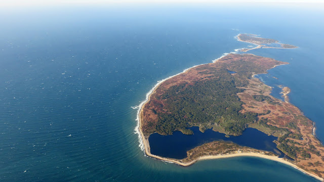
I passed Nashawena (foreground) and Cuttyhunk (background) Islands, the westernmost of the Elizabeth Island chain. Rhetorical question: who names these things?
Reaching the mainland, I formally entered the region covered by the turbulence AIRMET from 2,000 to 10,000 feet. To my surprise and delight, the air remained remarkably smooth. In fact, the entire trip home at 4,500 feet was generally smooth.
Narragansett Bay is home to Aquidneck Island, best known for Newport, RI.
 |
| Newport, RI and Newport State Airport (frame left) |
 |
| Narragansett Bay with Providence, RI in the distance |
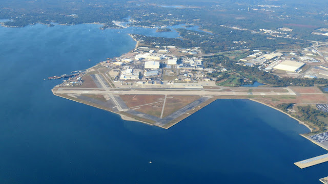
A distinctive layout betrayed Quonset State Airport's 1940s military origins.
 |
| Providence, RI |
Unexpected Color Tour
I awoke that morning expecting an unpleasant slog home, prepared to be shaken and bounced around for four hours straight. Imagine my surprise when that was not the case, another example of an AIRMET Tango crying wolf. Yes, the flight was slow due to the headwind, but it was a pleasant slog rather than an unpleasant one.
I passed Bradley International, home to the schizophrenic ATIS.
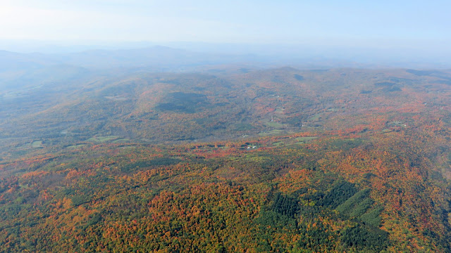
Desolate western Massachusetts was aglow in autumn color. I may not have made it to the Adirondacks that day, but my desire for a fall color tour was nonetheless satisfied by the vista spread beneath my wings.
The Catskill Mountains, lurking in the gloom off my left wing, sent a few mild downdrafts my way.
While in radio contact with Albany Approach, a Mooney joined the frequency, broadcasting with a warmly mellifluous voice seemingly made for radio. It caught my attention and I envied the pilot's confident radio persona. Then he dropped a PIREP that was of value to me. "Approach, smooth air above 3,000, moderate [turbulence] below."
Good to know.
Near Cooperstown, Boston Center provided a vector around the airport to accommodate a skydiving drop zone. It was clear that the Center controller was a trainee and that he was anxious about the parachute activity. He vectored me much farther around Cooperstown than necessary.
When the jump plane announced that there would be no more jumping that day due to increasing winds, relief was palpable in the Center controller's response. "Oh, that's excellent!" effused the controller a little too emphatically.
As I left 4,500 feet to descend toward Sodus, I crossed an invisible demarcation near 3,000 feet below which the Warrior was wracked with turbulence. That Mooney pilot's PIREP was remarkably applicable, even though I was significantly west of Albany. Having been lulled into complacency by over three hours of smooth air, I was startled by a series of abrupt staccato jolts. I tightened my seatbelt and continued down through the churning maelstrom of mechanical turbulence created by the surface wind.
It is a given that the Sodus AWOS lies, so I cannot confidently state what the winds were actually doing when I landed. But the peak gusts were declared to be in the mid teens rather than the mid-30s as forecast and, while the atmospheric chaos swirling over the runway did not lend itself to a greaser of a landing, it was all very manageable without having to divert elsewhere. The decision to fly home early was a wise one because the already blustery day simply became more so as the afternoon wore on.
Thus ended another successful exploration of a wonderful new place, all facilitated by my humble Warrior. Martha's Vineyard was a very worthwhile destination. With the abrupt forecast changes, I reaped little benefit from an overnight stay on the island and that was frustrating to me. But this is the trade-off for the way that aviation shrinks the world. Without an airplane, I may not have ever gone there at all.


No comments:
Post a Comment