Day 2: Outer Banks Exploration
The sun in the Outer Banks is way more intense than it is in New York. I greeted the dawn from the beach on the second day of our North Carolina sojourn. Though the morning air remained cool, direct sunlight on my skin felt much hotter than it would have at home. I had already decided that I needed to be much more diligent with sunscreen. Nonetheless, I savored the morning's ocean breeze and the tranquility of the beach.
We planned to depart First Flight Airport in four aircraft and follow the barrier islands as far to the southwest as Ocracoke. Along the way, we would see the region's famous lighthouses and explore the airports we encountered.
Our final destination of Ocracoke is the most remote island in the Outer Banks, separated from the mainland by 16 nautical miles of open water in Pamlico Sound and only reachable by boat or aircraft. It was once a haven for pirates such as the fearsome Blackbeard who used the island for cover before attacking and plundering unsuspecting ships.
Return to First Flight
| Date | Aircraft | Route of Flight | Time (hrs) | Total (hrs) |
| 31 Jul 2023 | N21481 | FFA (Kill Devil Hills, NC) - HSE (Hatteras, NC) - W95 (Ocracoke, NC) - FFA | 2.7 | 2685.6 |
 |
| Dan standing in front of the Centennial of Flight sculpture. |
We hiked back to First Flight Airport as the day rapidly warmed, coming first upon the Centennial of Flight statue. Head down with his phone, Dan appeared to be utterly oblivious to the presence of a glorified box kite that appeared to be bearing down on him with a 10 mph ground speed. Good thing it was actually a statue and any hint of motion from it was an illusion.
Orville's bronze gaze remained fixed on the horizon, just as it has for the last twenty years. As I studied the sculpture, I wondered why the artist chose to orient the Flyer broadside to the prevailing wind. Sometimes, "pilot brain" is just hard to shut off.
Tom joined Wilbur Wright in a synchronized wing-running exercise. Honestly, it was really hard to tell which of them was which, but it helped to know that Tom was the one in Technicolor.
This air conditioned oasis in the sweltering Carolina heat is sponsored by the Aircraft Owners and Pilots Association (AOPA). It was built in 2003 as a pilot lounge and flight planning room in celebration of the Centennial of Flight. It is also an artifact of a time when thorough flight planning had transitioned from just a telephone to computer-based tools and imagery, but before Foreflight arrived on devices carried in everyone's pocket (with apologies to Android users). While our cellphones made the computer terminal redundant, the air conditioning was still very pleasant.
It was here that we reunited with Dave, who made the short drive south from Duck that morning and joined us for a day of island hopping. It is always great to have Dave along.
We unbundled our drowsing aircraft and made them ready for flight.
Flying the Strand
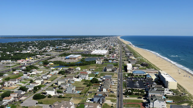 |
| View looking north on departure from First Flight Airport. |
Four aircraft from the Williamson Flying Club launched from runway 3 of First Flight Airport that morning. Afterward, each pilot made the same observation about the heightened density altitude affecting their ability to clear trees at the end of the runway. Everyone made it of course, but all received a not so subtle reminder about the effect of heat on aircraft performance.
 |
| First Flight Airport and the Wright Brothers National Memorial. |
Tom and I flew a wide arcing turn to the left around First Flight, rolling out on a southerly heading and climbing to altitude. Much of the Outer Banks is a designated wildlife refuge area that requires aircraft to operate at or above 2,000 feet. We cruised at 2,500 feet.
 |
| Me and Tom flying along the barrier islands. |
Across Roanoke Sound from Bodie Island (home to Kill Devil Hills and Kitty Hawk), we could see the Dare County Airport (MQI) in Manteo on Roanoke Island. I landed there during my first flight to the Outer Banks in October 2011. That was an important flight for many reasons. It was my first pilgrimage to the Wright Brothers National Memorial, it was the day I logged my 1000th flight hour, and it included the incident that made me realize it was time to pursue an instrument rating.
Dare County is named for Virginia Dare, the first English colonist born in the New World in 1587. Young Virginia, along with the other members of the Lost Colony on Roanoke, mysteriously disappeared from the site sometime between 1587 and 1590. Historians speculate that the colonists were absorbed into Native American communities, but details are few.
 |
| Nag's Head, NC with Jennette's Pier visible. |
 |
| US-64 bringing road traffic to Nags Head on Bodie Island. |
A system of bridges and causeways carry traffic from the mainland, across Roanoke Island, and ultimately to Bodie Island.
As I observed in 2011, the marshland surrounding the southern tip of Roanoke Island is cut with numerous razor-straight artificial channels.
 |
| Bodie Island Light Station. |
A lighthouse has stood guard over the treacherous Outer Banks shore near the Oregon Inlet since 1847. The first incarnation was built on a shoddy foundation and had to be abandoned by 1859. A replacement lighthouse was built that same year, but was destroyed by the Confederacy in 1861 out of fear that Union soldiers would use it to their advantage. The current lighthouse, the first to be sited north of the Oregon Inlet, was completed in 1872.
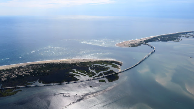
Oregon Inlet is the waterway between Bodie and Pea Islands. Vehicle traffic passes between the islands on NC-12 (apparently, the highway is not for children under the age of 12?) on the Basnight Bridge completed in 2019. It replaces the older Bonner Bridge from the 1960s that I would have seen on my previous trips.
As shown in this photo, a portion of the Bonner Bridge has been retained on the Pea Island side of the inlet as a fishing pier.
Pea Island is home to a National Wildlife Refuge and is distinguishable from the air by a series of unusually shaped ponds that show obvious signs of human intervention.
Roughly 11 miles south of its northern tip, Pea Island becomes Hatteras Island. Although Pea Island is currently conjoined with Hatteras, the dynamic sands of the barrier islands have resulted in periodic disconnections of Pea and Hatteras Islands over time. In fact, my aerial photos of the Outer Banks from 2011 clearly show the "New Inlet" opened by Hurricane Irene (August 2011) that severed Pea Island from Hatteras for several years.
As explained by Dave, the road into Rodanthe, NC once ran along the beach on the ocean side and was often inundated by seawater. The aptly named Jug Handle Bridge was completed on the protected side of the barrier island to solve this problem in 2022. Also visible in this photo is the "Eye of Rodanthe".
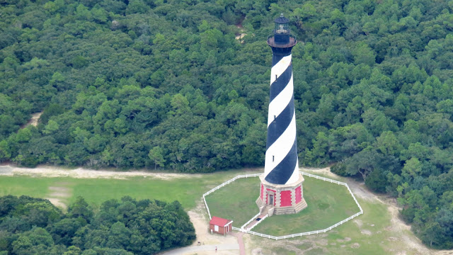
Cape Hatteras is known as the "Graveyard of the Atlantic" due to the Diamond Shoals, an extensive grouping of shifting underwater sandbars that have wrecked hundreds of ships. In recognition of this danger, Congress authorized construction of a lighthouse in 1794 that was ultimately completed in 1803. The resulting 90 foot tall sandstone lighthouse was ineffectual because it was too short, its beacon too weak, and the sandstone exterior blended in with local dunes. Over time, the lighthouse was fitted with a more effective light, increased in height by 60 feet, and the top half was painted red for daytime visibility. But that was still not enough.
The current structure was first lit in 1870 and was dressed with its iconic helical black and white stripes in 1873 as a unique "daymark" for recognition. Towering 198.5 feet over the island, it is the tallest brick lighthouse in the United States. The National Park Service provides a terrific virtual tour of the Cape Hatteras Lighthouse on their website.
Friendly Fire
 |
| Left base for runway 7 at Billy Mitchell. |
The airport on Hatteras Island bears the name of Billy Mitchell, the Brigadier General who was such a staunch advocate for air power in the early twentieth century that he is considered the intellectual father of the United States Air Force. There is even a bomber named after him, the twin engine B-25 that was central to the famous Doolittle Raid over Tokyo during WWII. In 1923, Mitchell orchestrated a demonstration during which bombers launched from Langley Airfield, flew 175 miles to Cape Hatteras, and bombed a pair of military surplus ships (the New Jersey and the Virginia) anchored there. The job was finished by other bombers launched from a temporary airfield on Hatteras and demonstrated that aerial bombardment could sink ships. Although today's airport is not in the same location as that temporary field, it carries Billy Mitchell's name in honor of his 1923 bombing demonstration along the Hatteras coastline.
 |
| Final, runway 7 at Billy Mitchell. Photo by Tom. |
We flew past an impressive array of massive beach houses on final for runway 7, ultimately overflying beachgoers before touching down at Billy Mitchell (HSE, airport #264). While it was no St Martin, it felt decidedly odd to fly low(ish) over people on the beach before landing.
 |
| Dave and Ed arrived in Ed's snazzy repainted Archer II. |
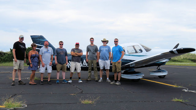
Once everyone was down and parked at Billy Mitchell, we took the obligatory group photo (me, Kim, Scott, Gilead, Dave, Dan, Ed, and Tom).
 |
| Dan with One Delta Tango. |
We were all giddy about landing at a cool island airport adjacent to the beach. It was not the kind of place that our club planes usually frequent.
Reaching the beach was a simple matter of crossing the runway (look both ways!) and climbing over a line of dunes.
 |
| A photo of me taking photos of others. Very meta. Photo by Gilead. |
Why did the pilot cross the runway? To get to the beach, of course!
Footprints marked the path back to the airport.
To the southwest toward Ocracoke, a minor weather system made for a gloomy sky, but the worst of the weather was sufficiently over the Atlantic that we were not concerned.
Tom modeled the latest in aviator beach apparel.
Vegetation on the dunes formed a portal between the idyllic beach and the airport.
Once we returned to Billy Mitchell Airport, a pair of aircraft flew over in formation.
"Are those Mustangs?" asked Tom. From directly below, I noted the squared off wingtips and a discernable whistle from the slipstream.
"Maybe!" (They weren't.)
Once aloft, we heard the pair on frequency with callsigns Devil 1 and Devil 2 setting up for landing at Ocracoke and knew that we would catch up to them soon.
 |
| Hatteras, NC. |
Ocracoke - Cola Vegetable?
 |
| Hatteras-Ocracoke Ferry. |
Ocracoke and Hatteras Islands are separated by the Hatteras Inlet. Aside from air travel, the only way on or off Ocracoke Island is by a ferry that requires an hour to transit the inlet. By comparison, our aircraft covered the distance in mere minutes. On our way to Ocracoke, we passed the ferry loaded up with cars and bound for Hatteras.
 |
| The Hatteras-Ocracoke Ferry crosses Hatteras Inlet. |
Hatteras Inlet hosts a crab spawning sanctuary in an effort to bolster the local blue crab population.
As we crossed Hatteras Inlet, details of the slender tendril of Ocracoke Island sharpened. Clouds in the distance were dropping rain, but we expected the worst of the weather to miss us.
 |
| Ocracoke Island Ferry Terminal. |
 |
| Ocracoke Airport in sight! It did not look like much. |
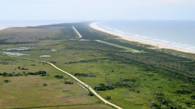
Tom and I were third out of the four WFC aircraft inbound to Ocracoke. A fifth aircraft was farther east behind us and also inbound. Then there was 55T, a Cessna approaching from the southwest and on an opposite heading to the rest of us. He called that he was inbound for the same runway (6) with an intended midfield crosswind entry. If he executed on this plan, it meant that he would cut into our line of arriving aircraft.
This should be interesting, I thought. It was not clear to me how the Cessna was going to be able to merge into the line of arrivals safely. Fortunately, he did not try. While his radio calls were a muddled mess, our traffic displays showed him loitering west of the airport waiting for traffic to clear. That was a good choice on his part.
 |
| Northeast end of the Ocracoke Airport. |
As the WFC aircraft all broadcast their position reports in the pattern, the pilot of Cessna 55T chimed in with, "Is this a convoy?" It is not just Air Traffic Control that comments on our group fly-outs! In all fairness, he had no idea that the fifth aircraft in line was not a part of our group.
 |
| Southwest end of Ocracoke Island. 55T was loitering out there somewhere. |
 |
| Left base, runway 6, Ocracoke Island. |
 |
| WFC aircraft parked on Ocracoke Island. |
Oceana's Devils
As soon as I saw the pair of turbine-powered T-34 Mentors parked at Ocracoke, I realized my mistake at Billy Mitchell. They were obviously not Mustangs, though they were cool in their own right. A little bit of internet sleuthing revealed that the Devil callsigns are specific to turboprop T-34s based at Naval Air Station Oceana near Norfolk, VA.
They might be glorified Bonanzas, but the paint jobs had undeniably cool WWII-inspired flair.
 |
| Dave says, "Hi! I'm in Ocracoke!" |
Domain of the Quartermaster
Howard's Pub is the nearest dining establishment to the airport. In the old days, a Pub staffer would pick up aviators in a six seat golf cart. That is no longer the case, but the walk was easy. As we walked, we received a light spritzing as the weather's edge passed Ocracoke. It was just enough rain to spot the windscreens of all the airplanes.
Howard's Pub is an institution on Ocracoke, built by Ron Howard in 1978. (Narrator: Not that Ron Howard.) The Howard family is descended from Ocracoke Island's original owner, William Howard. It is a name that comes with some controversy.
Born in coastal North Carolina in 1686, a William Howard served aboard Queen Anne's Revenge as the quartermaster for Edward Teach, better known as the pirate Blackbeard. Despite being captured and sentenced to hang, Howard escaped the noose through good fortune in the form of a royal pardon from King George I. Little is known about Howard's post-piracy life and it was not until decades later in 1759 that a William Howard purchased the island. It is unclear whether the notorious pirate and the William Howard that purchased Ocracoke were the same man, but the possibility exists.
Interestingly, when Kristy, The Bear, and I first visited Howard's Pub in 2013, the menu aggrandized the Howard family's potential buccaneer roots. In 2023, no mention of this connection remains on the restaurant's official website. I wondered if this was due to uncertainty surrounding the Howard family's connection to piracy or a simple desire to rebrand.
 |
| Tom, me, Dave, Scott, Kim, Gilead, Dan, and Ed. Photo by Tom. |
Inside, Howard's Pub presents a cluttered motif of out of state license plates and college banners from around the world. I even spotted a pennant from Western Michigan University in Kalamazoo. Just as in 2013, the lemonade brought relief from the effects of a hot day. Tom shared a delicious seared Ahi tuna appetizer. Our food was actually better than I recalled and I was glad to see that they still served kid meals on frisbees. This was a good stop.
Rounding the Cape
 |
| Apron at Ocracoke Airport. |
 |
| Dave and Ed prepare Four Four Papa for the journey back to First Flight Airport. |
 |
| Looking northeastward along Ocracoke Island on departure from runway 6. |
 |
| Hatteras Inlet. |
 |
| Southwestern tip of Hatteras Island. |
As we relived the journey to Ocracoke in reverse, I noticed that the storm-ravaged Frisco Pier that extended from the shore in segments back in 2013 had been removed entirely.
 |
| Billy Mitchell Airport on Hatteras Island. |
This time, we rounded Cape Hatteras on the ocean side of the island.
 |
| Looking north along Hatteras Island. |
 |
| Rodanthe, NC and the Jug Handle Bridge. |
Continuing northbound, we passed the distinctive ponds of the Pea Island National Wildlife Refuge. As before, we stayed above the minimum cruise altitude of 2,000 feet.
 |
| Oregon Inlet. |
 |
| Oregon Inlet. |
When the sun emerged, it brought with it the beautiful colors of the confluence of land and sea.
 |
| Bodie Island (foreground), Roanoke Island (middle), and the mainland (background). |
 |
| The Outer Banks Fishing Pier, Nags Head, NC. |
 |
| Jennette's Pier in Nags Head, NC is the largest fishing pier in the Outer Banks. |
The Wright Brothers Never Had To Deal with Traffic
We returned to First Flight Airport mid afternoon and flew over the magnificent granite monument perched high on Kill Devil Hill.
As we overflew the airport for a teardrop entry into the traffic pattern for runway 3, we spotted Gilead, Scott, and Kim landing perfectly on centerline in Eight Five X-Ray.
 |
| Warrior 481 landing at First Flight. Photo by Scott. |
After touchdown, we overheard some drama on frequency when a pilot departed Manteo and declared that he was landing on runway 21 at First Flight. This was a poor choice because it was not only downwind, but in the opposite direction already being used by traffic in the pattern. His declared pattern entry method placed him in direct conflict with Dan and Ed. After a rebuke from Dan over the radio, the other pilot skedaddled and took his poor judgement elsewhere.
 |
| Warrior 481 in front of the Wright Brothers National Memorial at First Flight Airport. Photo by Scott. |
 |
| Dave emerged from Four Four Papa having arrived at First Flight by air for the first time. |
I caught pictures of Dave and Ed standing proudly before the Wright Brothers National Memorial. Then I thought, wait...aren't you supposed to face Mecca? If this was mecca for aviators, was it appropriate to turn one's back to it? Then I realized that this scene unfolded following Ed's second landing at First Flight. Clearly, the wonderment of the first landing had been replaced by a ho-hum / old-hat kind of attitude.
 |
| Dan with the four WFC aircraft tied down at First Flight Airport for our second night. |
Palindrome
That night, Ed, Dan, Gilead, and I enjoyed Mexican food at 3 Tequilas. Naturally, there were margaritas involved because they are a must when you dine at a place with "tequila" right in the name.
I ended the day the same way I began it, back at the beach. This time, it was with some of the other WFC members rather than taking in the ocean air alone.
 |
| "Say hello to my little friend!" |
As the sun set, we even found a little friend on the sand.
Reflecting on the day, I believe that everything we saw reinforced what I have said since my first flight to the region in 2011. There is no place quite like the Outer Banks and the aerial vistas truly need to be seen to be believed.


