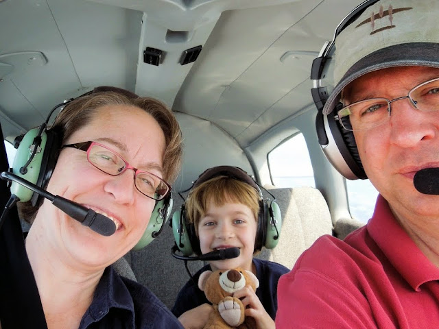
Mission: Relaxation
After a long summer, time for our auspicious "second annual" summer retreat with Kristy's family had arrived. Two points may define a line, but not always a reliable trend. Still, a successfully planned second gathering goes a long way toward establishing a bona fide tradition. My personal goals for the trip included (1) not thinking about work, (2) relaxing with a good book or two, (3) not thinking about work, (4) playing with The Bear, and (5) not thinking about work.
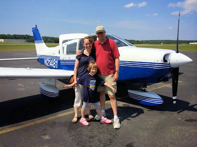
From our various corners of the nation, we converged on Ocean Isle Beach, NC. Kristy and I did not know much about the region prior to our visit. We were to learn that August in this part of the country is beyond hot and that the region is home to palmetto bugs, sort of a southern gentleman's name for cockroaches; big ones that emerge at night to graze the concrete prairie surrounding the swimming pool.
Planning
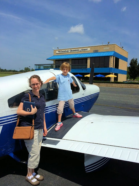
Three airports were available for our use. The modest Odell Williamson Municipal Airport in Ocean Isle Beach itself; Grand Strand Airport in nearby North Myrtle Beach, SC; and Cape Fear Regional Jetport / Howie Franklin Field in Oak Island, NC. Somehow, it struck me as strange to fly from Williamson to Williamson. In truth, Odell Williamson would have been the best choice when I was VFR only. However, it has no instrument approaches available, which would place limitations on arrival and departure conditions (maintaining the rule of thumb that one should not depart an airport in weather conditions that do not permit a return). The other two airports, more or less equidistant to the south and north, were more capable in terms of approaches, providing more flexibility. Of the two, Cape Fear Regional Jetport had the lowest parking fees, so it won. The airport manager, Howie Franklin, is best known as the chief steward on Air Force One from 1976 to 1994 under five different presidents.
For the trip south, I planned to break the anticipated six hour flight into three legs. We would stop at Hagerstown, MD for fuel ($5.70 at the Rider Jet Center's self serve pump) and Dinwiddie County Airport in Petersburg, VA to meet
Jeff and his family for lunch. Though I have known Jeff for over ten years, since my earliest days on the Piper Owner Society forums trying to glean tribal knowledge about the airplane I had purchased, we have never met in person. From there, it would be a straight shot to Cape Fear Regional Jetport.
Quick Turn
| Date | Aircraft | Route of Flight | Time (hrs) | Total (hrs) |
| 16 Aug 2014 | N21481 | SDC (Sodus, NY) - HGR (Hagerstown, MD) - PTB (Petersburg, VA) - SUT (Oak Island, NC) | 6.3 | 1316.8 |
I filed, and was cleared, for a direct route from Williamson-Sodus to Hagerstown. With Kristy, The Bear, and our sixty pound suitcase loaded aboard the Warrior, we were en route at 8:00 am.
Monitoring 121.5 (the emergency frequency) en route, we heard an airliner inadvertantly broadcast that they had a couple of "specials" and would need two wheelchairs upon their arrival. Clearly, they were on the wrong frequency and meant to be communicating with their own ground staff.
"Are the two specials sitting up front?" queried a gruff voice. There was no response from the airliner.
Over the southern tier of New York State and proceeding into Pennsylvania, seas of mist pooled around the bases of higher terrain. Closer to Hagerstown, our clearance was amended to direct SCAPE intersection, then direct Hagerstown. We arrived to find an active field with significant traffic inbound for an EAA fly-in that morning.
We taxied directly to Rider Jet Center's self-service pump and refueled. This pump has the best fuel hose rewinding reel I have ever seen. Though it may seem a silly thing to remark upon, I was truly impressed. It is a wheel of large diameter and only as wide as the hose itself, resembling a giant film reel. Like a film reel, the hose rewound neatly without the chaotic jumble that usually ensues when using typical fuel pumps. I was so taken with the well-engineered machine that I regret not having the presence of mind to photograph it. Wondrous device.
For any airport, it was a quick turn fuel stop. The fact that we had such a "no muss, no fuss" experience at a towered airport was terrific. As we taxied away from the fuel pump, we could hear another aircraft approaching from behind, powered by an old radial judging by the way it snorted and snarled. Sure enough, it was a Stinson Reliant.
We received our IFR clearance from the tower and taxied to the departure end of runway 27. We were delayed somewhat because the tower controller had his hands full with another pilot departing the EAA gathering who was clearly unaccustomed to processing "tower-speak". Tower issued a taxi clearance that would require at least two runway crossings and use of a small handful of taxiways. The pilot was simply not processing this information. After several exchanges, the tower controller said, "ok, let's make this easy. Turn left and proceed to the end of runway 9 for departure." It would be a downwind departure, but on a rather long runway and the wind was light. Clearly, the controller deemed this to be safer than trying to direct the fellow to the other side of the airport where we were waiting for IFR release at runway 27.
We received our take off clearance and were handed off to Potomac Approach before reaching pattern altitude. Filled with baggage, fuel, and people, Warrior 481 climbed about as enthusiastically as I take the stairs after gorging myself on Thanksgiving dinner. It was clearly inadequate for Potomac Approach, who assigned a "climb vector" before clearing us direct to the Linden VOR.
Dinwiddie
On approach into Dinwiddie County Airport in Petersburg, VA, I was made anxious by the skydiving operation ongoing there. I do not regularly operate around any airports with parachute activity and am not entirely comfortable with applying see-and-avoid practices to bodies dangling under canopies. Nonetheless, I spotted the orange dot of the final canopy drop toward the field while still some distance out.
As we taxied onto the ramp, I paused to contemplate parking. The radio crackled.
"Chris, you can go ahead and park next to that Citation." I am not accustomed to being addressed by name upon arrival to a new airport, but could see the UNICOM operator talking on a handheld radio and standing next to Jeff and his family.
"Daddy," commented The Bear before I powered down the airplane, "the D-word on that building is funny."
Indeed, it was.
 |
| Photo by Jeff F. |
Dinwiddie County Airport was originally built as a stopover point for World War II aircraft ferried from east coast factories to the Pacfic. From above, the facility obviously once possessed the classic triangular runway configuration typical of WWII era military fields, but at least one of the runways was almost completely erased from the Earth and another was significantly reduced in size. Still, the people were friendly, the fuel was reasonably priced for the area, and the terminal building was very nice. My biggest challenge with Dinwiddie was pronouncing it on the radio in such a way that it did not come out "dimwitty" (and if it ever did, I offer that it was purely by accident).
 |
| Photo by Jeff F. |
We had a wonderful lunch with Jeff and his family. The Bear took to his kids right away, Jeff and I have more in common than I originally realized (including some mutual friends and some past geographies - evidently all roads lead to, or perhaps from, Kalamazoo), and, as "airplane wives", Kristy and Lori seemed to be cut from a very similar cloth. There was an easy rapport with some nice people and kindred spirits.
Flirting with Cumulus
Back in the sky, we broke one of my cardinal rules for flying south in the summer by departing at 3:00 pm for a two hour flight. Convective activity was under way, but fortunately, it was not widespread.
Still, it was a delight to legally flirt with edges of the buildups. Most new instrument pilots are very excited to go barreling through clouds once they earn their ratings. Most also learn very quickly that such behavior can lead to some very rough rides in building cumulus; I know that I did. Where the clouds were obviously building with vigor, we made minor deviations to slalom around them. It is probably the closest I will ever come to flying one of those Red Bull race courses and it was a lot of fun.
In some cases, deviations were completely unnecessary and the clouds just seemed to part around the invisible line defining our trajectory.
Stratus revealed a smallish thunderstorm to the left of our course, meriting a slight deviation west to avoid it. This was approved by Seymore Johnson Approach. As we passed the beastie, the world beneath it was lost in shadow and mist.
Though some weather existed in the vicinity of Cape Fear Regional Jetport, the field was VFR when we arrived. Continuing a theme for the day, the field was actively hosting skydiving operations.
Once certain that all the jumpers were on the ground, we circled southeast of the airport and over the Atlantic coast before entering the pattern.
While I looked around to clear the area, I noticed that The Bear was watching the world go by with rapt fascination.
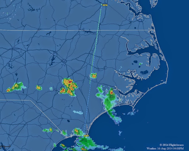 |
| FlightAware radar track from PTB to SUT. I do not know why some data are missing, but our deviation around the small cell is clearly depicted. |
A lineman at Cape Fear Regional directed us to parking, assisted with tying the airplane down, and even lugged that heavy sixty pound suitcase to a golf cart for transport to Kristy's parents' car. Then he vanished before I could tip him.
As we left Cape Fear Regional for the week, I made a mental note to check the belly of the airplane for Robert DeNiro (or Sideshow Bob) before departing.
"...And Back Again"
| Date | Aircraft | Route of Flight | Time (hrs) | Total (hrs) |
| 21 Aug 2014 | N21481 | SUT (Oak Island, NC) - JGG (Williamsburg, VA) - D38 (Canandaigua, NY) - SDC (Sodus, NY) | 7.0 | 1323.8 |
I spent portions of our vacation time planning the return trip, which included a huge ForeFlight update that sucked significant household bandwidth one evening. Forecasts showed that a low pressure system would be sitting on Rochester, NY for a few days, suggesting unsettled weather at home. Nonetheless, forecasts did not indicate any significant weather systems beyond isolated thunderstorms. I planned to fly to Williamsburg, VA with a landing at the Williamsburg-Jamestown Airport for fuel and food at Charly's. From there, we would fly north through the Washington DC SFRA and on to home.
We drove through patchy fog en route to the airport, but found conditions to be solidly VFR on our arrival. The Warrior had endured a couple of storms during her time on the ramp at Cape Fear Regional, but there was no water in the cabin and no obvious new hail dents.
Though it was only 9:00 am, we sweltered on the surface of the airport. Lining Warrior 481 up on the runway, I could feel a river of sweat flowing between my shoulder blades. I gave the airplane full throttle and she lethargically trudged forward along the runway until reaching flying speed in the high density altitude.
From ForeFlight, I expected an airway route from Cape Fear to Williamsburg, but Wilmington Approach cleared us direct. En route, we listened to the drama playing out with Six Six Delta. Our controller was a trainee, but her trainer had to step in several times to deal with Six Six Delta. The aircraft departed Manteo in the Outer Banks and was attempting to receive an IFR clearance from Washington Center in the air. A low ceiling prevented him from climbing to the minimum vectoring altitude and the trainer, who could not see the aircraft on radar, refused to issue a clearance. When Six Six Delta complained, the controller noted that, "perhaps you should not have departed that airport VFR." Something told me that the errant pilot would be receiving a phone number to call at some point, but we were switched to a new sector and did not hear how Six Six Delta's adventure ended.
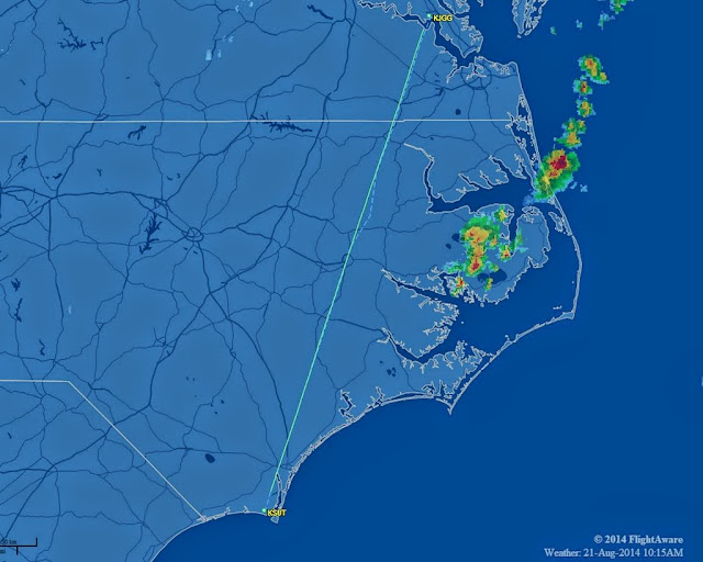 |
| FlightAware radar track from SUT to JGG |
On approach into Williamsburg-Jamestown Airport, Norfolk ("Nawf'k") Approach called to give us a new approach frequency. Upon switching, a new controller immediately instructed us to contact a different frequency. On that frequency, we were immediately given yet another frequency. Making that change, we were issued yet a third frequency. I half expected the crazy radio round robin to end back with our original controller, but we finally landed on a suitable frequency and proceeded inbound to Williamsburg.
Lunch at Charly's
Joining the right hand traffic pattern for runway 13, it became very obvious to me that I was tired. I misjudged the downwind to base turn, finding myself too close and too high to land. I eased the Warrior into a slip, realized that this tactic was futile, went around, and did a much better job of it the second time.
 |
| In her photos, The Bear seems to be trying to recapture the magic from Watertown, NY. |
I chose Williamsburg-Jamestown Airport because reviews claimed that Charly's restaurant was small but excellent. It was. We arrived a little early for the lunch crowd and were seated right away, but the small restaurant soon filled with patrons. Our food was good, priced appropriately, and served with mellow hospitality by our harried waiter. The Bear particularly enjoyed the little playground located adjacent to the terminal building.
I let ForeFlight suggest an airway route from Williamsburg back to Sodus. It was: HCM V33 OTT PALEO BAL EMI HAR V31 BEEPS. I filed this while waiting for lunch to arrive and soon received an email verifying it as the expected clearance.
As The Bear played on the playground equipment, I sat in the Warrior and dialed my expected route into the Garmin. The airways (V33 and V31) present the most problems because the GNS-430W does not recognize them, meaning that I needed to define them by fixes describing their meandering courses through the sky. V31, for example, zig zags over central Pennsylvania and New York as defined by the Harrisburg, Selinsgrove, Williamsport, and Elmira VORs. It was an exercise in serious knob turning for a few minutes.
As we prepared to depart, a Coast Guard helicopter settled on the ramp. This really excited The Bear. After all her time spent flying in light airplanes, I think she's destined to be a helicopter pilot. Helicopters always grab her attention in ways that airplanes - while still interesting to her - do not.
Because I have never used one, I tried using the field GCO (ground communications outlet) to get my clearance from Norfolk. Keying the microphone the requisite number of times did not produce anything useful and I opted to pick up the clearance while airborne. Norfolk cleared us as filed and we gratefully clawed our way up to cooler altitudes.
Reroutes
When Norfolk handed us off to Potomac Approach, we heard, "Warrior 481, I have a new route for you. Advise when ready to copy." So much for "cleared as filed". I sensed some more knob turning in my immediate future. The new clearance was: direct COLIN PXT V93 BAL, then as filed (i.e., the route would still end with EMI HAR V31 BEEPS). Still climbing, I deleted the obsolete waypoints from the GPS, referred to the chart to obtain the appropriate defining fixes for Victor 93, and dialed all the new information back into the navigator. I found myself under high workload, dividing my time between the navigational challenges and keeping the Warrior on the correct heading. This generally meant making minor heading corrections between setting waypoints. If I felt tired on arrival at Williamsburg, I was really feeling it now.
Once the system was reprogrammed and we reached cruise altitude, I relaxed slightly. Then we were transferred to Patuxent Approach who immediately noted yet another new route.
"Ready to copy," I responded, working to keep the dismay out of my voice. After all, re-routes are common in congested airspace and no one was subjecting me to any unfair treatment.
"Warrior 481 is cleared to Sierra Delta Charlie via direct LOUIE, T291 (my first T-route!), Harrisburg, Victor three one, BEEPS, direct, maintain seven thousand." I was back to the drawing board with even more knob twisting. Once the navigator was reprogrammed again, I triple checked the clearance against the chart and the GPS. It would not do to misinterpret the clearance and have an unauthorized deviation within the most secure airspace in the United States. Or more accurately,
near the most secure airspace; our final clearance kept us entirely outside the Washington DC SFRA.
We encountered our first significant cloud build up while on with Patuxent Approach. I asked for a slight deviation to the right.
"Can you go left or right?" responded the Patuxent controller whom I had mistakenly addressed as "Potomac Approach" at least twice because I was still a little task saturated. When I responded in the affirmative, Patuxent approach continued, "good, because there's a restricted area to the right."
"Warrior 481 will deviate left."
"Great idea!" cheered the Patuxent controller. In my defense, we were already in the middle of restricted airspace on our clearance to LOUIE.
Shall We Talk About the Weather?
Over Baltimore, larger build ups presented themselves and I undertook a significant deviation around a cluster of them. Stratus reassuringly displayed those areas with intense rainfail and, though we were surrounded by clouds, we were generally in the clear. I deviated around those that I could and picked smaller ones showing little vertical development to punch through. There was some chop in these, but none of it significant. In the blind, the instruments would deviate a bit from their desired readings and I would lightly push, pull, and twist until those needles returned to where I wanted them to be.
When we first entered the clouds, Kristy groaned. However, a faint sound of clapping originating from The Bear could be heard. In this way, they are so very different.
Approaching the Harrisburg VOR, my eyes told me that there was a monstrous brute directly ahead. When flying a mile and a half above the countryside and a massive mountain of cumulonimbus seems to extend up to low Earth orbit, this is a clear sign of something to be avoided. Per Stratus, the leading edge of the beast was thirty miles away. It is important to understand with Stratus, however, that the data are already old when uplinked to the airplane and we were downwind of the thunderstorm cell. Distance data should be interpreted with margin for error. The Harrisburg VOR was five miles away, however, and upon reaching it, we would change course out of the path of the monster.
The beast floated over the world, rearing up so as to blot out the sun. As we entered its shadow, Kristy was visibly nervous. To her eye, I was playing chicken with that cell. All of the available data suggested to me that it was still tens of miles away.
We reached the Harrisburg VOR and turned northeast on Victor 31 toward Selinsgrove, moving out of the path of the cell. Stratus depicted two more cells directly in our path. I coordinated a plan with Harrisburg Approach who used their real-time radar to provide a vector around them to the east. After a few minutes on an assigned heading, we were cleared direct to the Hazleton VOR to give the weather an even larger margin of safety.
Along the way, we passed through some light rain. "Warrior 481, say flight conditions," called Harrisburg.
"In the clear, light rain, smooth ride," I responded. The controller seemed pleased to hear this in his acknowledgement. We passed smoothly through some clouds and, eventually, emerged into VFR conditions.
Behind us, shadows from the storms over Selinsgrove cast the world into darkness.
Before we reached the Hazleton VOR, Wilkes-Barre cleared us direct to Williamson-Sodus and handed us off to New York Center.
I dialed the new frequency and nudged the flip flop to make it active. Center was talking to another aircraft, so I held my peace awaiting quiet air to check in. Before I could do so, Center broadcast, "Warrior 481, Binghamton altimeter is 30.03."
Kristy and I exchanged surprised looks. It was the first time I had ever had a check-in acknowledged on frequency without ever actually checking in. His clairvoyance evidently did not extend to airliners, however. "Airliner ABC, were you planning to comply with your restriction?" he asked without obvious malice.
It was something of a relief to leave Pennsylvania behind, as though the legislated state boundary could somehow contain the nasty weather rampaging through the Keystone State. The Stratus radar picture for our route through New York looked more promising.
Elmira Approach was happy to grant multiple diversions around towering cumulus. We passed one cloud dousing the landscape with rain.
We stayed mostly in the clear, navigating smoothly through canyons defined by churning masses of turbulent vapor.
In the distance, a three headed hydra worked to build itself into a titan.
Over the Finger Lakes, we emerged from the maze of clouds as if from a tunnel. Realizing that I was tense, I pulled my feet off the rudder pedals and flexed my toes, creating a ripple of metatarsal tectonic activity that relieved some of the strain with a satisfying crackle.
 |
| Photo by Kristy |
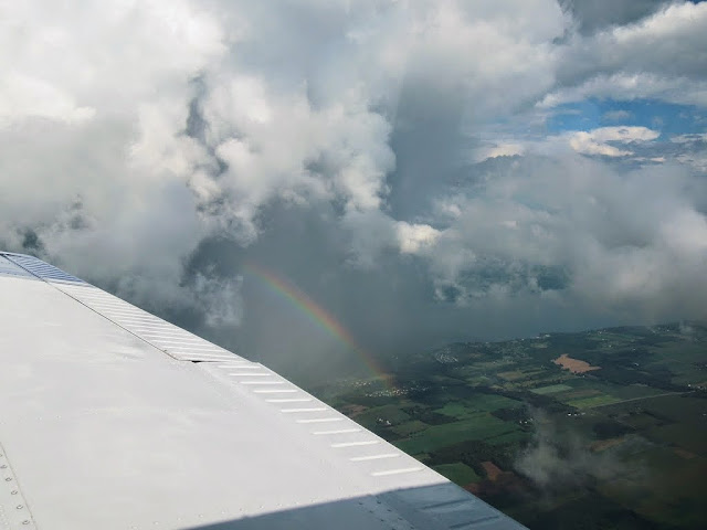
Flying past Seneca Lake, we saw the rainbows. It was Kristy's first time seeing rainbows from the air. The last time I saw a rainbow while aloft was during my first solo flight in 2001.
But we were soon to learn that we were far from home free. This is why I really do not believe in omens.
Deviation
Fifteen minutes from Sodus, Stratus showed the area to be clear and the airport's automated weather station was calling good VFR conditions. After a long slog of a flight from Virginia, we were almost home.
"Warrior 481, there's a large cell with extreme precipitation near Sodus that will impact your route of flight." This from Rochester approach. Ahead, there was a vague shadow in the distance, but the haze made it difficult to identify visually as a cell. Stratus showed no radar returns in the region. I acknowledged the information and took a moment to think.
The sun, streaming into the cockpit over my left shoulder, added enough glare to the iPad screen that I almost did not see it: the time stamp of the last weather update was displayed in red and indicated that thirty minutes had passed since the displayed radar data were received. Thirty minutes!? The Stratus continued to communicate with the iPad and indicated that it was receiving information from three FAA ground towers. But the weather picture on my iPad was frighteningly out of date. I was left with no time to troubleshoot further.
Wreathed in haze and shadow, I could not discern the weather that Rochester warned me about, its distance, or its relative position to home. Off our port wing, Canandaigua was in the clear. It was time to reassess from the ground.
"Rochester Approach, Warrior 481 would like to deviate to Canandaigua."
"Warrior 481, that's approved. Can you verify that this is a deviation for weather?"
"Affirmative, 481." We turned left, away from the shadow.
 |
| FlightAware radar track from JGG to D38 |
The last time I landed at Canandaigua was when I
diverted there because of weather over Le Roy four years ago. Evidently, the place is a good port in a storm. In the pattern, Kristy wondered aloud how long it would take The Bear to realize that something was amiss.
As it turns out, not long. Clearing the runway, Kristy switched The Bear off of isolate in time for us to hear, "hey! This isn't
our airport!" She is an astute Bear. On the bright side, she got to add a new airport to her map as was the case for every field we visited on this trip (she is up to 64).
We spent forty minutes on the ground as an intense, isolated cell audibly rumbled between our location and Sodus. While there, we met Brian who works at the airport and owns a Cherokee 180. It was just repainted on-site and he brought me into the hangar to show off his pride and joy. To my eye, the paint shop did good work. Brian offered us cold water and enlisted The Bear's help in some simple arithmetic, a challenge she met proudly.
I also met a student pilot from the Buffalo area who was wearing a Duncan Aviation shirt. When I asked him about it, I learned that he had family ties back to Kalamazoo, which was the origin of the shirt.
It really is a small world after all.
Drained
We made the brief hop home sans iPad, Stratus, or the watchful eye of Rochester Approach. The cell that caused our diversion had lumbered east, having developed into a classic anvil shape (above). We skirted the bit of clag left in its wake to land at home after 7.0 hours of flying.
I have been flying for twelve years as a certificated pilot and, in that time, have made some long flights. But I have never been more exhausted after a flight than I was after this one. Maybe I was poorly rested from the start. Maybe the unfamiliar weather environment, both spectacular and foreboding, was particularly draining. Maybe it was a combination of all those things plus the presence of my family on board. Regardless of the reason, I was absolutely bone-tired.
Despite that, I felt that the flight went well, that I made good use of the resources available to me (particularly ATC and ForeFlight/Stratus), and that my decision making was sound. Stratus seemed particularly useful in prompting questions to ATC about the weather in order to get their real-time assessment. I found myself using Stratus strategically, but leveraging ATC and my own eyes for developing tactics.
I also came to appreciate that an autopilot might be a really good idea someday.
Best of all?
There was no evidence of Robert DeNiro clinging to the belly of the airplane since our departure from Cape Fear Regional Jetport.


