Friday, September 25, 2009

Unlikely Hues and Airport Improvement

Date Aircraft Route of Flight Time (hrs) Total (hrs)
25 Sep 2009 N21481 5G0 (Le Roy, NY) - N66 (Oneonta, NY) - 5G0 3.1 765.8

I love this time of year.

Most of the year, farm country is entirely monochromatic.  Winter white fields melt to reveal chestnut earth waiting to produce life.  In time, signs of life arrive as a rich green carpet across the countryside.  But in fall, before succumbing to a winter blanket once more, the fields display a vast array of improbable colors.


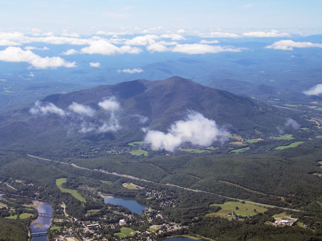
I found myself above the planet on a quiet Friday afternoon after a long, difficult week.  I had never seen the Catskill Mountains and decided that it was time.  As I flew over the Finger Lakes, familiar fields exploded with the unlikeliest of hues.  Purple fields?  To paraphrase Ralph Wiggum, "that's unpossible!"

 
I fought a rare easterly headwind and simply reveled in the kaleidoscope world below.


In time, the Catskills came into sight (not pictured) and I stopped at Oneonta (N66, airport # 97) for a brief rest.  Oneonta is perched on the top of a wooded hill, a mere slot in the trees wide enough for a single runway and tightly clustered hangar buildings.

Having reached the doorstep of the Catskills, I chose to head home rather than explore further.  I promised Ray that I would take some pictures of the Le Roy airport that evening and wanted to take advantage of the golden light provided by the evening sun.


Le Roy recently completed a runway extension, lengthening from 2640' to 3855'.  With the longer runway now open for use, Ray terminated the ban on touch and go landings at Le Roy.  After nearly four years based at Le Roy, I did my first touch and go there that afternoon.

I arrived at the airport eager to experience the new runway.  Le Roy has always been subject to squirrelly winds.  With the runway 28 approach end moved farther east, I wondered what quirks the new runway microenvironment would offer approaching aircraft.  The cruel joke of the day was the rare wind from the east, forcing me to use runway 10.  As a result, Warrior 481 did not once roll upon new pavement or sample the new approach.


Completion of the runway extension project came less than a week after USA Today published a biased article on general aviation airports entitled, "Little Used Airports Cost Taxpayers Big Money".  I don't normally read USA Today, but I happened to be on a business trip September 17 and the article was waiting for me outside my hotel room door that morning.

The intended take-home message of the article is that taxpayers are being gouged by "little airports" (i.e., those shunned by American Airlines and Delta) that receive grant money from the Airport Improvement Program.  How so?  Because airline ticket taxes are an income source for this fund.  And why should taxpayers be angry?  Because they may not personally use an airport that the fund benefits.

Yes, the Airport Improvement Program (AIP) is funded by tax dollars.  Those tax dollars come from several sources, including fuel taxes paid by every pilot that buys gas.  Airports receiving AIP money are public use facilities that the FAA deems worthy of receiving grants.  Public roads, public parks, and public schools and even unpopular wars all receive tax dollars in much the same way.  In the judgment of the article (a paragon of objective journalism), little airports don't merit public funds because fewer people use them than, say, Chicago O'Hare.  It's a curious kind of logic.  Would we not build a road to a small town?  Would we not allow a suburban school district to exist because it is smaller than the New York city school system?  The fact of the matter is that little airports are training grounds for future airline pilots, they allow companies to transport personnel and equipment close to far flung sites, they provide rural access to advanced medical care, they are fueling depots for crop dusting aircraft, and they are centers of recreation.

Did Le Roy deserve funding to extend the runway?  The FAA thought so.  Le Roy is a designated reliever airport for Greater Rochester International.  This does not mean that your United 737 flight is going to divert to Le Roy if things get hairy at Rochester.  It means that Le Roy provides a place for general aviation traffic to go, thus relieving congestion at the main airport.

The runway at Le Roy was too short for even some light aircraft, meaning that it was less effective as a reliever airport.  Training flights often shunned Le Roy because touch and goes were forbidden owing to the short runway.  Ray proposed to the FAA that lengthening the runway will make Le Roy safer (I witnessed an accident earlier this year in which the relatively short runway was a factor) and a more effective reliever for Rochester.  The FAA agreed and supported the extension work through AIP money.  The project focused on practical safety and security improvements: lengthening the runway, lighting it appropriately for night landings, and fencing it all in.  Contrary to implications by USA Today, many AIP grants are just like Le Roy's: safety and security improvements intended to improve the overall national airspace system.

Sunday, September 13, 2009

Simple Pleasures

Date Aircraft Route of Flight Time (hrs) Total (hrs)
13 Sep 2009 N21481 5G0 (Le Roy, NY) - DSV (Dansville, NY) - 5G0 1.1 762.7

On the second Sunday of every summer month, EAA Chapter 486 at the Oswego County Airport hosts one heck of a fly-in breakfast.  From the mandatory pancakes to homemade doughnuts prepared on site, it's quite an operation.  For one reason or the other, we were unable to attend any breakfasts this year.  September 13 was the last one of 2009; the herald of season's end.

The glorious blue skies over Rochester belied the IFR (instrument) conditions prevailing over Oswego that morning as Kristy, The Bear, and I made ready to depart from Le Roy for breakfast.  We settled for a quick trip to Dansville for breakfast at the family restaurant within walking distance of the airport.


En route to Dansville, the mountain obscuration forecast for points south appeared as a thick ivory blanket on the horizon between us and The Keystone State.  A thick tendril of fog spilled from the higher terrain, twisting and creeping along the Genesee River valley (above).  We diverted south of Letchworth State Park to view the spectacle before alighting at Dansville for breakfast.  Under glorious blue skies, we flew VFR into Dansville as another aircraft on the radio announced an instrument approach to our original destination at Oswego County.

The striking image of ground fog meandering through the Genesee Valley remained fixed in my mind's eye for the remainder of the day.  Why?  What was so "striking" about it?  I contemplated the comparatively binary perspective of people on the ground, either entrained within the cold mist or living and breathing beyond the next hill, unaware of its existence.  As I flitted through the air a half mile above the terrain, I could simultaneously experience both points of view and see the grand design of it all.

Despite a cool morning, brilliant sunshine warmed the cockpit interior.  The Bear's eyelids fluttered as her delight in flying gave way to the seductive influences of warm sunshine and the smooth vibration of the engine.

Then I understood.  Our early morning flight was not about breakfast or staying proficient or circulating oil for the sake of engine longevity.  It was about the simple pleasures of flying: a unique perspective, the grand beauty of nature, and even the trace smile of a contentedly dozing toddler.  As an avocation under attack from seemingly all quarters, we sometimes forget about the simple pleasures that make it all worthwhile.

Friday, September 4, 2009

Live Free or Die (or Something to That Effect)


Date Aircraft Route
of Flight
Time (hrs) Total
(hrs)
04 Sep 2009 N21481 5G0 (Le Roy, NY) - LCI (Laconia, NH) 3.1 758.5
06 Sep 2009 N21481 LCI - GFL (Glens Falls, NY) 1.0 759.5
06 Sep 2009 N21481 GFL - 5G0 2.1 761.6


Kristy, The Bear, and I took to clear skies on a calm morning to visit our friends Ann and Greg in New Hampshire.  We had planned to go a few weeks ago, but the weather would not allow.  It was our second annual pilgrimage to their home in the White Mountains.


Over Syracuse, we observed these short cloud streets running orthogonal to the main cloud formation.

 
The air was significantly less humid than our trip last year; even distant mountain peaks in Vermont were visible with reasonable clarity.  This photo was taken at 5500 feet with full (12X) optical zoom on the camera.


This photo was taken looking northeast while on approach to Laconia Municpal Airport (visible as the grayish stripe at frame right).  The body of water in the foreground is Winnisquam Lake.  Beyond is the expansive Lake Winnipesaukee.  The White Mountains can be seen in the background.  Lots and lots of water in this area - it reminds me of the aerial view over Oakland County, Michigan.

 
This capture from Flight Aware shows our actual radar track on the trip.  Occasional bumps and wiggles along our flight path show where we deviated around minor cloud buildups.  Once east of New York, we communicated primarily with Boston Center and, for the last bit of the flight, Boston Approach.  At one point while talking with Boston Center, the controller asked another pilot, "can you do Mach 0.8 or is that too slow?".  We didn't catch who he was talking to, but it was obviously not us.


After a couple of days with Ann and Greg, it was time to head back to New York.  We took this picture of Lake Winnipesaukee while departing from runway 8 at Laconia.  Love the color.

 
Lake Winnipesaukee reminds me of the Thousand Islands area of the St Lawrence River.  There are islands scattered everywhere!


More islands in Lake Winnipesaukee seen from a higher altitude; a truly beautiful sight.

 
This is the Ragged Mountain Ski resort, photographed shortly after we leveled off at 6500 feet for the flight home.  Can you say, "off season"?


As we crossed into Vermont, the terrain became more mountainous.  This ridge stood out because it was bare, as though someone had shaved it of trees with a giant razor.  In the distance is Mount Ascutney.

 
Another shot of Mount Ascutney.  This mountain is best known as Vermont's only monadnock ("lone mountain" - enhance your word power!).  Though its peak only reaches 3,143 feet, its isolation makes it stand out from a distance.  I think the town in the foreground is Windsor, VT.  Yay for situational awareness!  Ok, so I cheated and used Google after the flight was over.


More Vermont Mountains south of our route and immediately east of the New York border.


We stopped for lunch at Glens Falls, NY.  Glens Falls lies in the green valley pictured here.  This photo was taken looking north from just north of the airport.  I've said it before and I'll say it again: Floyd Bennett Memorial Airport in Glens Falls is a terrific place to visit.  It is active, well maintained, friendly, and home to "Carol's Airport Cafe".  All of Ann's talk about the best cheeseburgers in New Hampshire predisposed me to craving a cheeseburger.  Carol's makes a great cheesburger with the bun toasted just so.

We called Ann and Greg to tell them we had arrived at our lunch stop in New York and they were stunned.  "We just got back home from dropping you off at the airport!" Ann exclaimed.  I did not point out that New Hampshire and Vermont are tiny little states, but rather, allowed her to be impressed with the tremendous velocity at which we must have hurtled through the air.

The stop at Glens Falls was not all roses.  While sitting in Kristy's lap, The Bear's diaper leaked, which led to a quick change of clothes in the restroom after I rooted through Warrior 481's baggage compartment to find something sufficiently clean for both of them to wear.


As we left, our waitress presented The Bear with a little Styrofoam airplane.  The Bear was delighted with the little airplane (above, photo by Kristy), but managed to tear it in half before dozing off for her afternoon nap at 8,500 feet over the Adironacks.  She awoke during the descent into Le Roy and was quite displeased with the lack of toy airplane.  We bought her an unbreakable one on the way home from the airport as a consolation prize.

Our experiences with air traffic control that afternoon were varied.  From his responses, it seemed we caught the Griffiss controller napping with our initial call-up (surely not true, he was probably distracted with a landline call or some similar task).  From Syracuse, syllables tumbled through the radio so rapidly that I feared that I would not understand my own tail number.  Then, we were handed off to Rochester.  Though he was reasonably busy, the Rochester approach controller cautioned us about the NOTAMs at Le Roy for the nearly complete runway extension project.  I assured him that we were familiar with the NOTAMs, but was nevertheless very impressed that a moderately busy controller would take the time to provide extra information.  It was above and beyond the call of duty.  Thanks, to whoever you are.

Landings at Laconia and Glens Falls were nice, perhaps some of my best in recent memory.  Even though our landing at Le Roy was not quite as nice, our audience (Darrell and Neil) offered a score of "10".  No arguments from me.